Marvelous Nights in the Mountains


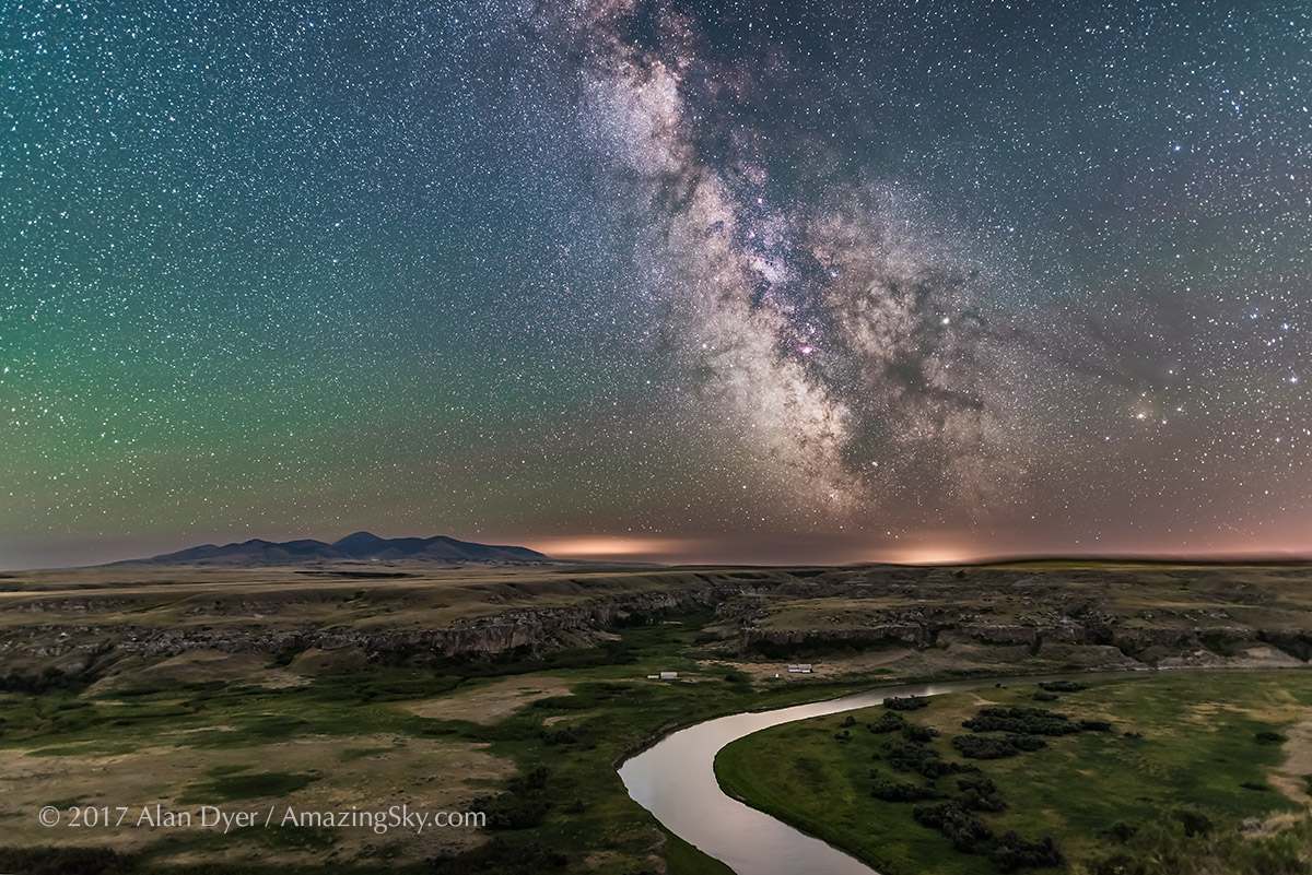
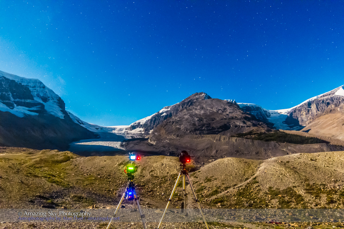
In mid-October 2022 I enjoyed a rare run of five clear and mild nights in the Rocky Mountains for shooting nightscapes of the stars. Here’s a portfolio … and a behind-the-scenes look at its making.

Getting two perfectly clear nights in a row is unusual in the mountains. Being treated to five is a rare treat. Indeed, had I started my shooting run earlier in the week I could have enjoyed even more of the string of cloudless nights in October, though under a full Moon. But five was wonderful, allowing me to capture some of the scenes that had been on my shot list for the last few years.

Here is a portfolio of the results, from five marvelous nights in Banff and Jasper National Parks, in Alberta, Canada. 

For the photographers, I also provide some behind-the-scenes looks at the planning and shooting techniques, and of my processing steps. 


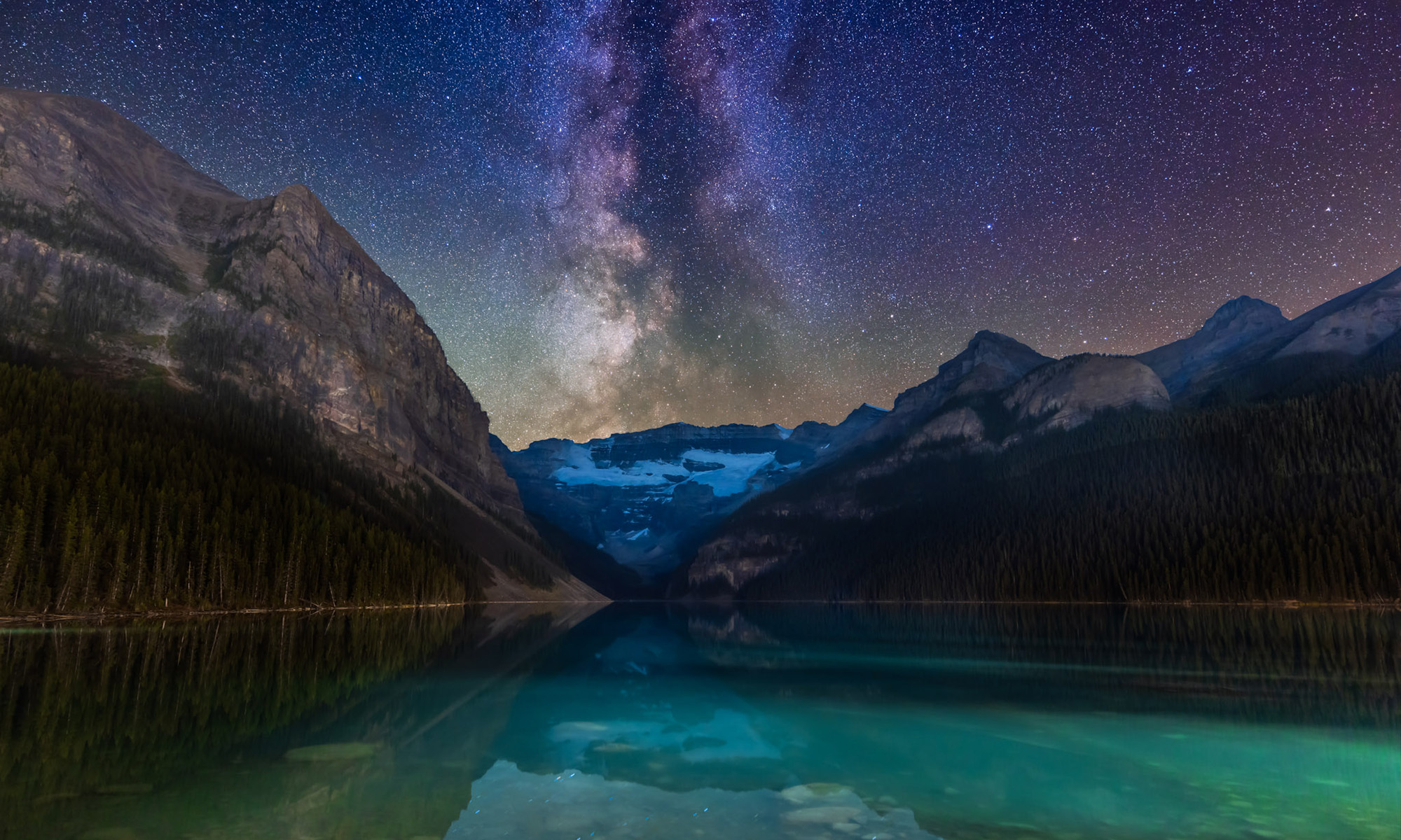
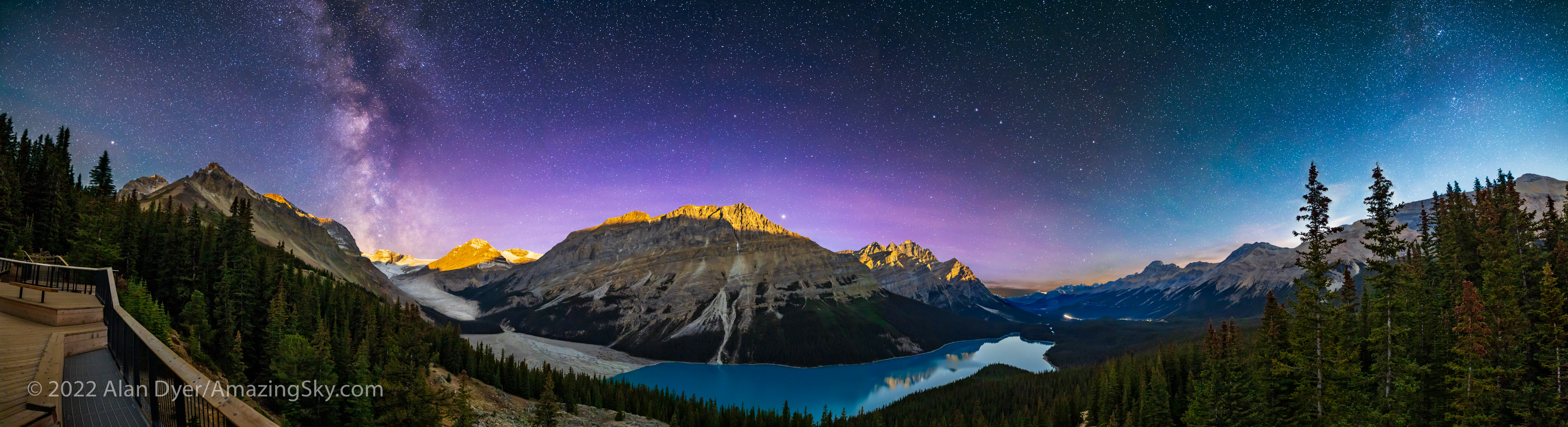
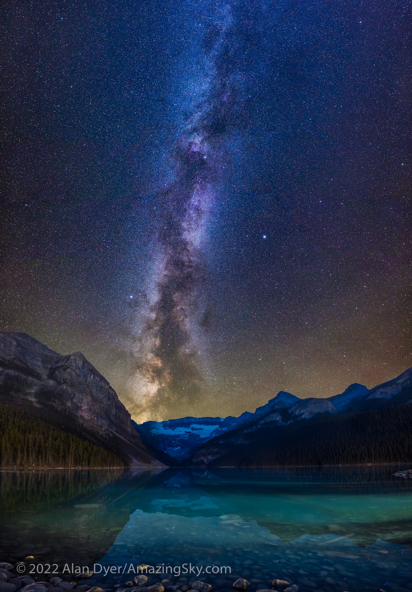
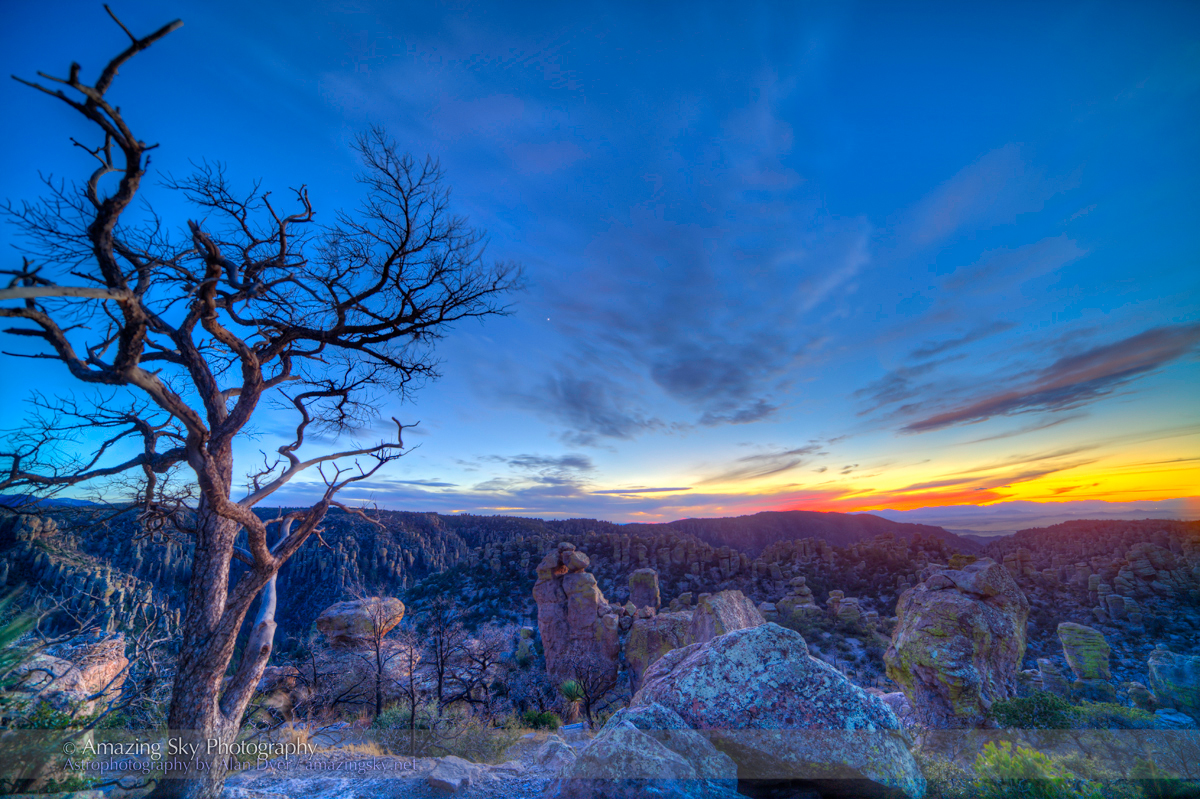
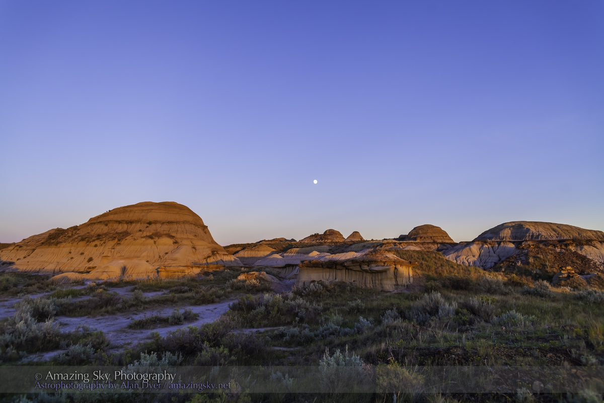
Night One — Peyto Lake, Banff National Park

Peyto Lake, named for pioneer settler and trail guide Bill Peyto who had a cabin by the lakeshore, is one of several iconic mountain lakes in Banff. Every tour bus heading along the Icefields Parkway between Banff and Jasper stops here. By day is it packed. By night I had the newly constructed viewpoint all to myself. 

The stars of Ursa Major, the Great Bear, over the waters of Peyto Lake, Banff, in deep twilight. This is a stack of 6 x 30-second exposures for the ground and a single untracked 30-second exposure for the sky, all at f/2.8 with the Canon RF 15-35mm lens at 15mm, and Canon R5 at ISO 800.

I shot the classic view north in deep twilight, with the stars of Ursa Major and the Big Dipper low over the lake, as they are in autumn. A show of Northern Lights would have been ideal, but I was happy to settle for just the stars. 

This is a blend of two panoramas: the first of the sky taken at or just before moonrise with the camera on a star tracker to keep the stars pinpoint, and the second taken for the ground about 20 minutes later with the tracker off, when the Moon was up high enough to light the peaks. Both pans were with the Canon RF15-35mm lens at 15mm and f/2.8, and Canon R5 at ISO 1600, with the sky pan being 7 segments for 1 minute each, and the untracked ground panorama being the same 7 segments for 2 minutes each.

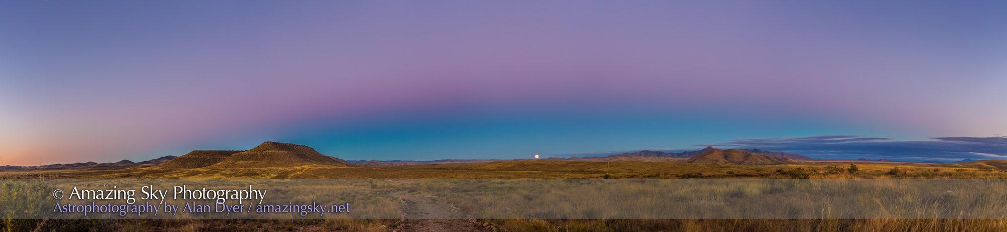
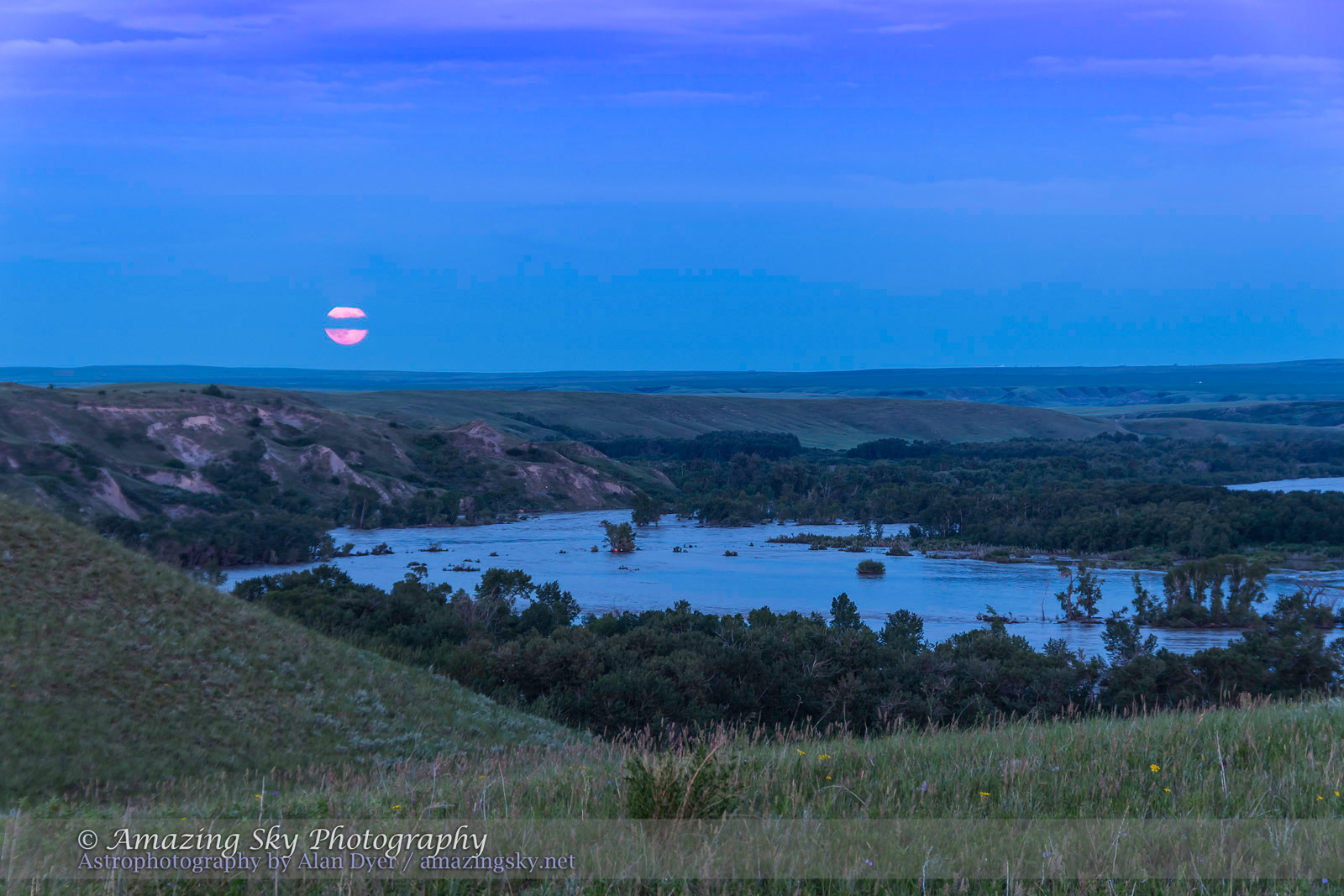
The night was perfect, not just for the clarity of the sky but also the timing. The Moon was just past full, so was rising in late evening, leaving a window of time between the end of twilight and moonrise when the sky would be dark enough to capture the Milky Way. Then shortly after, the Moon would come up, lighting the peaks with golden moonlight — alpenglow, but from the Moon not Sun. 

The above is blend of two panoramas, each of seven segments, the first for the sky taken when the sky was dark, using a star tracker to keep the stars pinpoints. The second for the ground I shot a few minutes later at moonrise with no tracking, to keep the ground sharp. I show below how I blended the two elements. 

The Photographer’s Ephemeris
TPE 3D

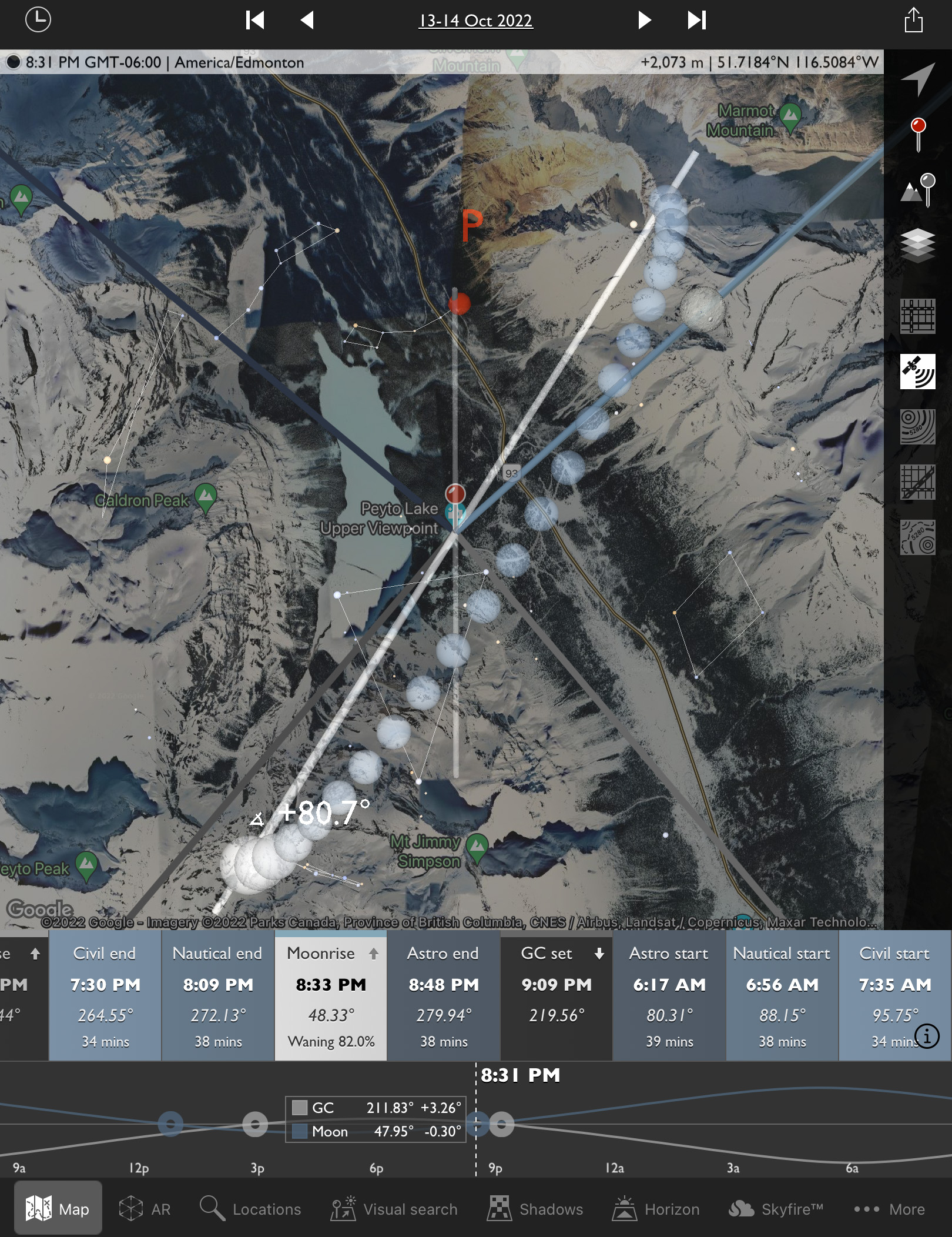
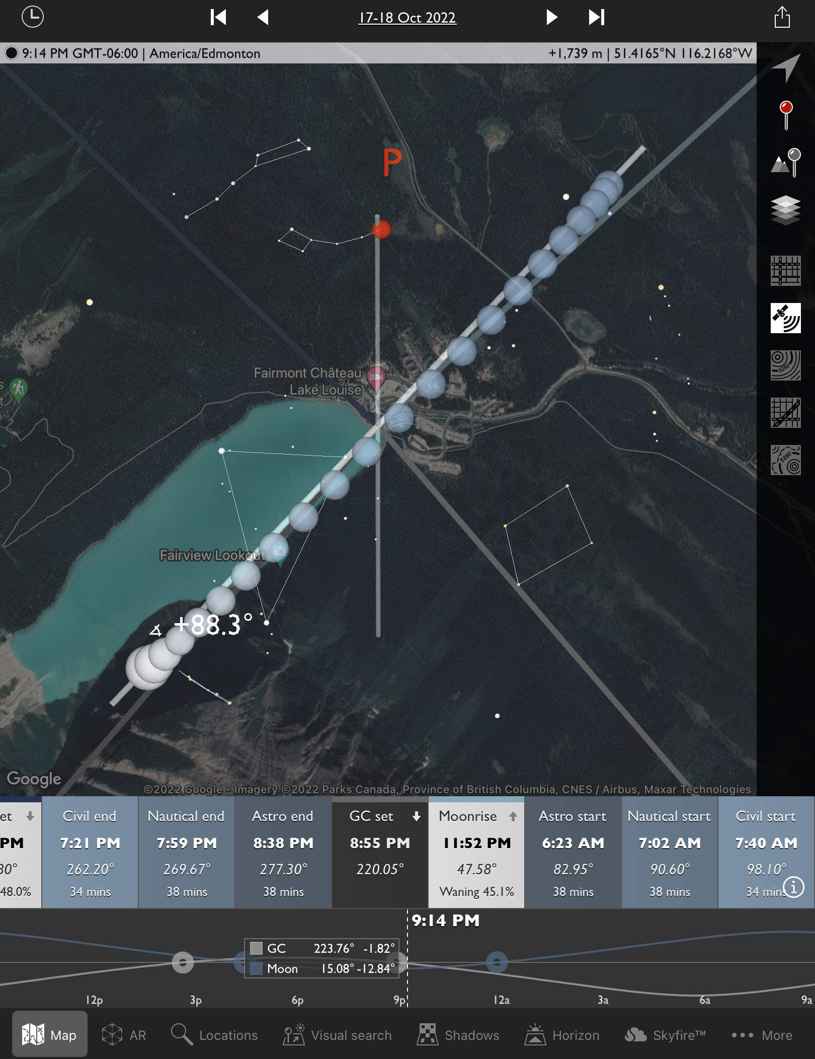
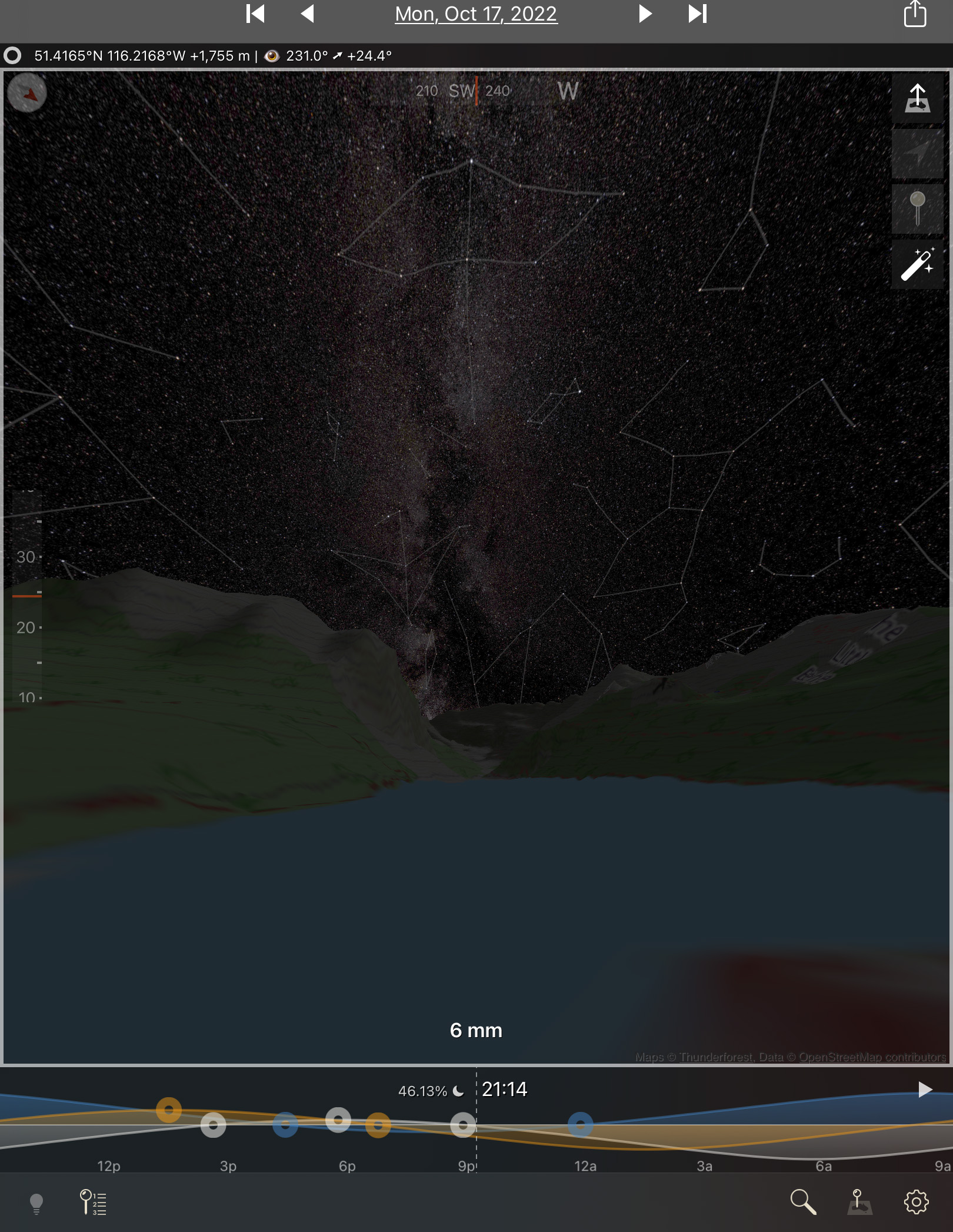
To plan such shots I use the apps The Photographer’s Ephemeris (TPE) and its companion app TPE 3D. The screen shot above at left shows the scene in map view for the night in question, with the Big Dipper indicated north over the lake and the line of dots for the Milky Way showing it to the southwest over Peyto Glacier. Tap or click on the images for full-screen versions.

Switch to TPE 3D and its view at right above simulates the scene you’ll actually see, with the Milky Way over the mountain skyline just as it really appeared. The app even faithfully replicates the lighting on the peaks from the rising Moon. It is an amazing planning tool.

This is a blend of 5 x 20-second exposures stacked for the ground to smooth noise, and a single 20-second exposure for the sky, all with the Canon RF15-35mm lens at f/2.8 and Canon R5 at ISO 1600. All were untracked camera-on-tripod shots.

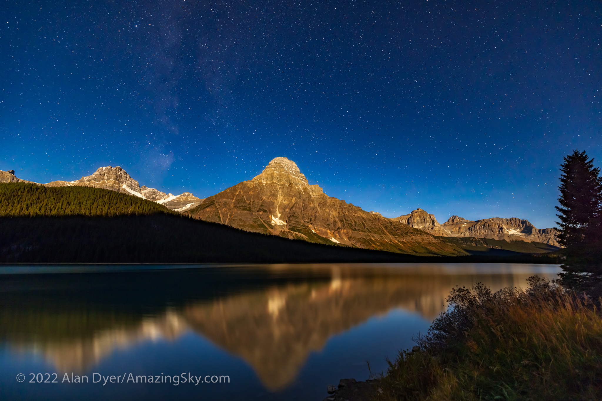
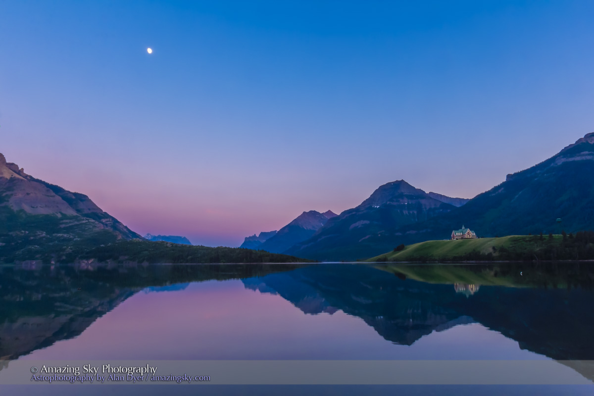
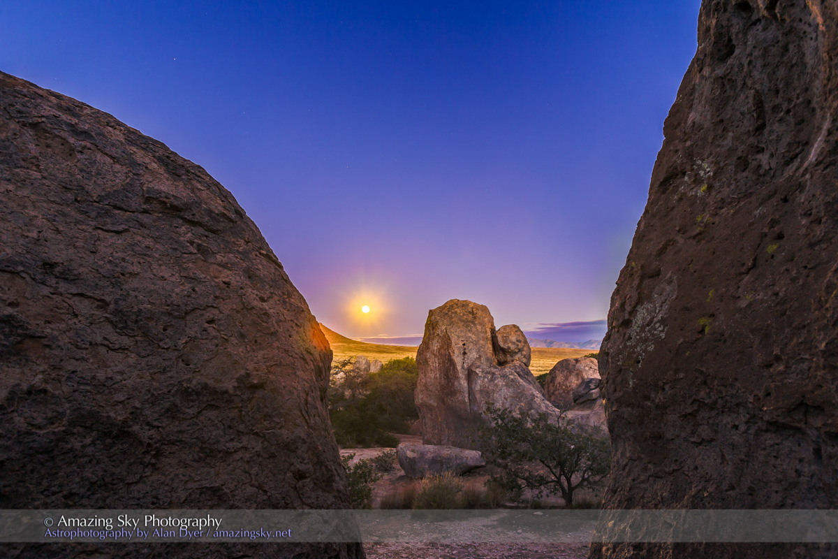
On the drive back from Peyto Lake to Saskatchewan River Crossing I stopped at another iconic spot, the roadside viewpoint for Mt. Cephren at Waterfowl Lakes. By this time, the Moon was well up and fully illuminating the peak and the sky, but still leaving the foreground dark. The sky is blue as it is by day because it is lit by moonlight, which is just sunlight reflecting off a perfectly neutral grey rock, the Moon! 

This is from a set of untracked camera-on-tripod shots using short 30-second exposures. 


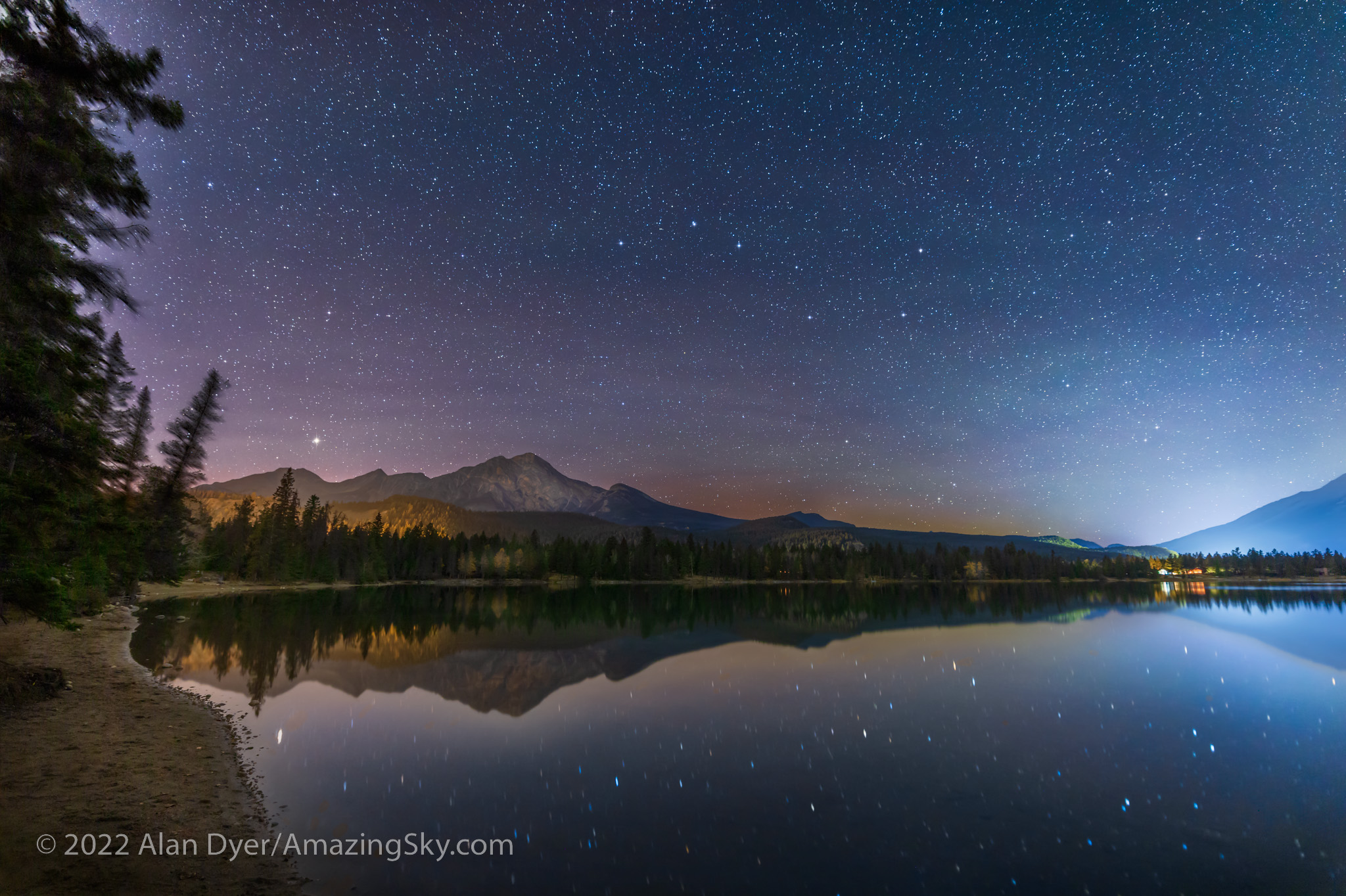
Night Two — Pyramid Lake, Jasper National Park 

By the next night I was up in Jasper, a destination I had been trying to revisit for some time. But poor weather prospects and forest fire smoke had kept me away in recent years. 

The days and nights I was there coincided with the first weekend of the annual Jasper Dark Sky Festival. I attended one of the events, the very enjoyable Aurora Chaser’s Retreat, with talks and presentations by some well-known chasers of the Northern Lights. Attendees had come from around North America. 

This is a blend of: a stack of 4 x 1-minute tracked exposures for the sky at ISO 1600 plus a stack of 7 x 2-minute untracked exposures at ISO 800 for the ground, plus an additional single 1-minute tracked exposure for the reflected stars and the foreground water. All were with the Canon RF15-35mm lens at 15mm and f/2.8 and Canon R5.

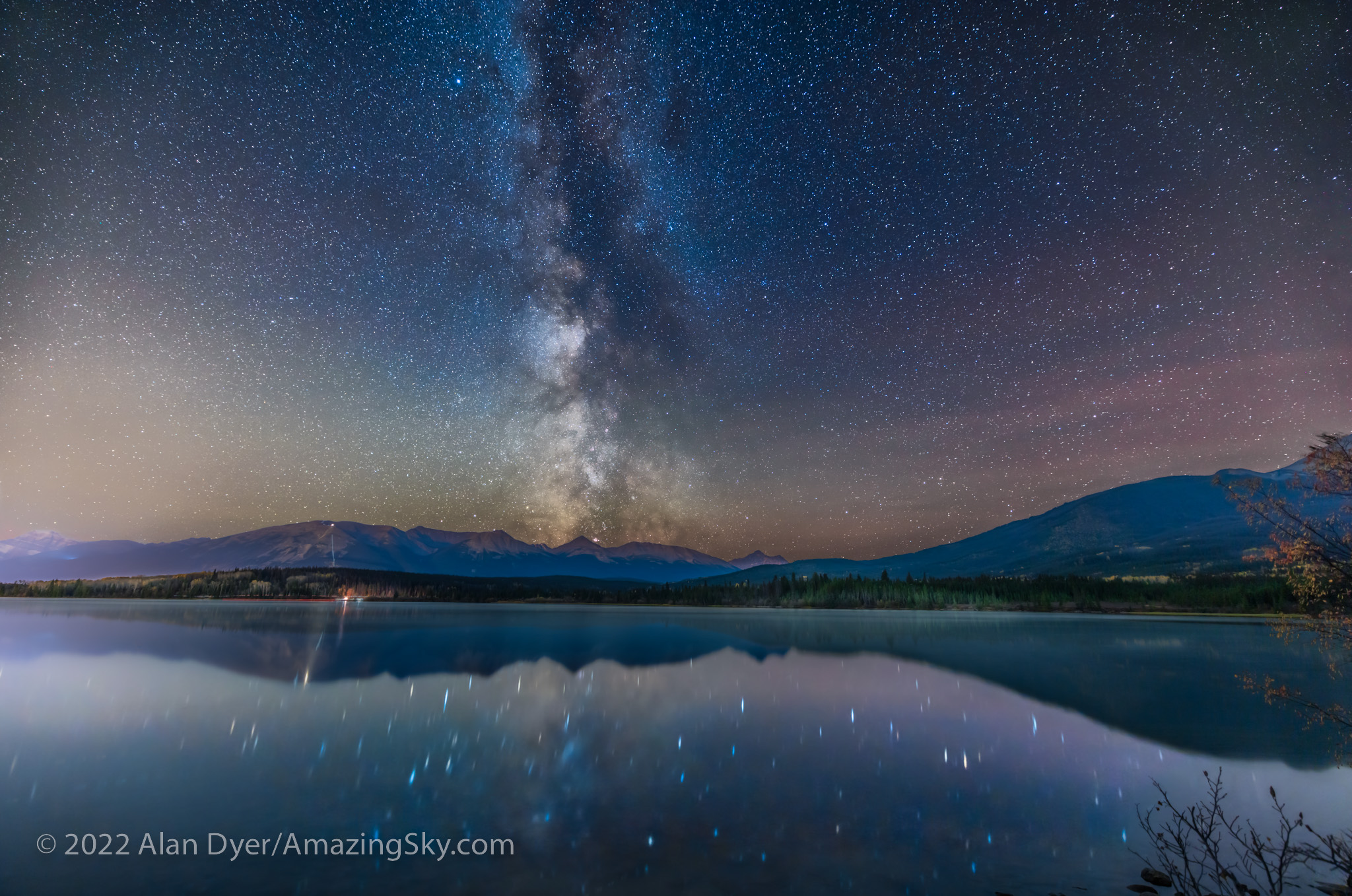
On my first night in Jasper I headed up to Pyramid Lake, a favorite local spot for stargazing and night sky photography, particularly from the little island connected to the “mainland” by a wooden boardwalk. Lots of people were there quietly enjoying the night. I shared one campfire spot with several other photographers also shooting the Milky Way over the calm lake before moonrise.

This is a blend of: a stack of 4 x 1-minute tracked exposures for the sky at ISO 1600 plus a stack of 6 x 3-minute untracked exposures at ISO 800 for the ground, all with the Canon RF15-35mm lens at 20mm and f/2.8 and Canon R5. The tracker was the Star Adventurer Mini.

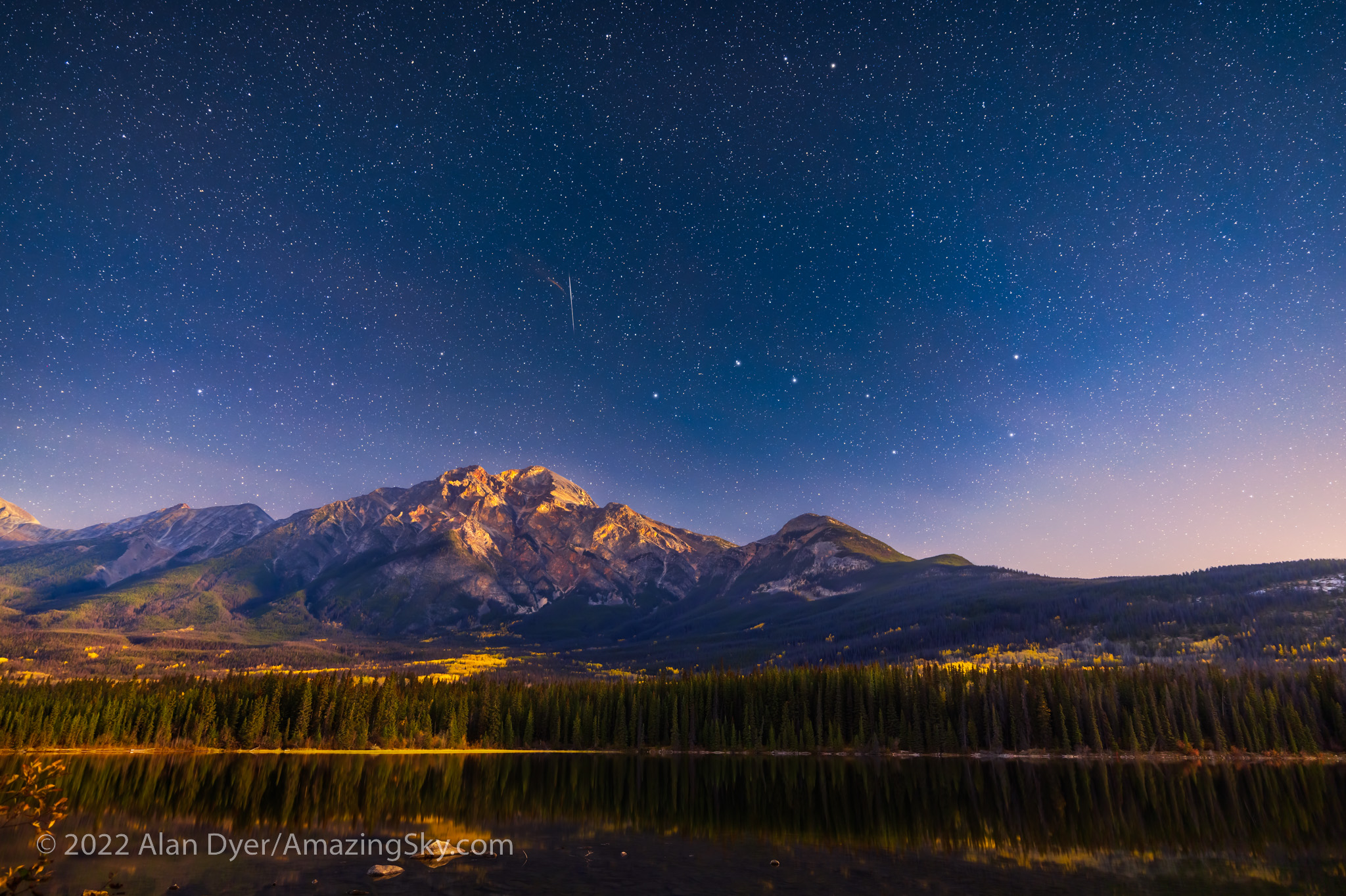
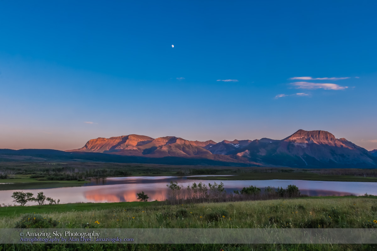
A little later I moved to the north end of Pyramid Island for the view of the Big Dipper over Pyramid Mountain, now fully lit by the rising waning Moon, and with some aspens still in their autumn colours. A bright meteor added to the scene.


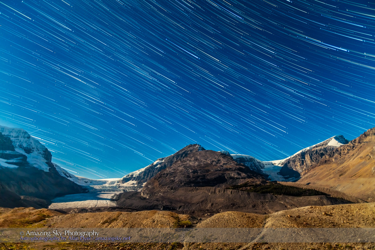
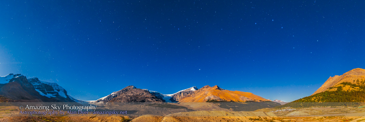
Night Three — Athabasca River Viewpoint, Jasper National Park

For my second night in Jasper, I ventured back down the Icefields Parkway to the “Goats and Glaciers” viewpoint overlooking the Athabasca River and the peaks of the Continental Divide. 

This is a blend of three 3-section panoramas: the first taken with a Star Adventurer Mini for 3 x 2-minute tracked exposures for the sky at ISO 800; the second immediately afterward with the tracker off for 3 x 3-minutes at ISO 800 for the ground; and the third taken about an hour later as the Moon rose, lighting the peaks with warm light, for 3 x 2.5-minutes at ISO 1600. All with the Canon RF15-35mm lens at f/2.8 and 15mm and Canon R5,

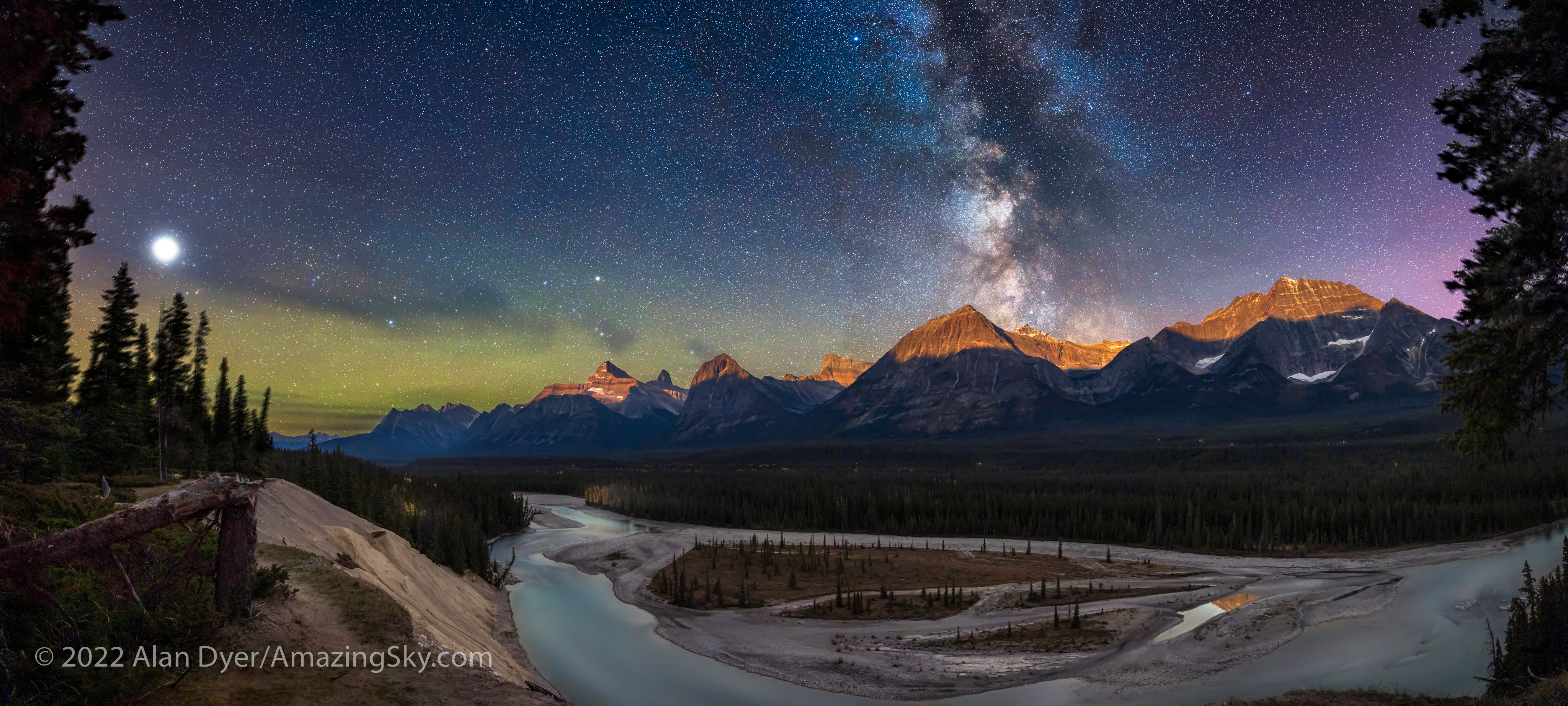
As I did at Peyto Lake, I shot a panorama (this one in three sections) for the sky before moonrise with a tracker. I then immediately shot another three-section panorama, now untracked, for the ground while it was still lit just by starlight under a dark sky. I then waited an hour for moonrise and shot a third panorama to add in the golden alpenglow on the peaks. So this is a time-blend, bending reality a bit. See my comments below! 


Night Four — Edith Lake, Jasper National Park

With a long drive back to Banff ahead of me the next day, for my last night in Jasper I stayed close to town for shots from the popular Edith Lake, just up the road from the posh Jasper Park Lodge. Unlike at Pyramid Lake, I had the lakeshore to myself. 

This is a panorama of four segments, each 30 seconds untracked with the Canon RF15-35mm lens at 15mm and f/2.8 and Canon R5 at ISO 1000.

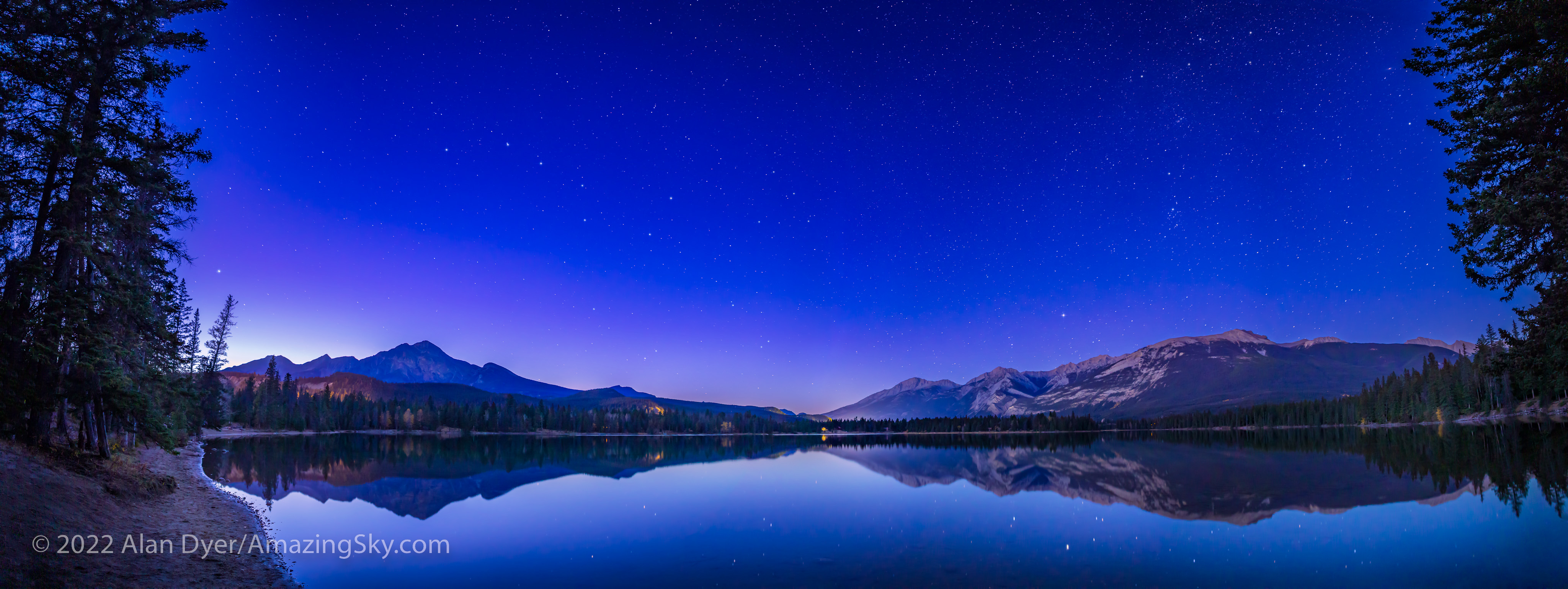
This would be a fabulous place to catch the Northern Lights, but none were out this night. Instead, I was content to shoot scenes of the northern stars over the calm lake and Pyramid Mountain. 

This is a blend of a single tracked 2-minute exposure for the sky and water with the reflected stars, with a single untracked 4-minute exposure for the rest of the ground, both at f/2.8 with the Canon RF15-35mm lens at 17mm and Canon R5 at ISO 800.
This is a blend of a single tracked 2-minute exposure for the sky and water with the reflected stars, with a stack of two untracked 3-minute exposure for the rest of the ground, both at f/2.8 with the Canon RF15-35mm lens at 17mm and Canon R5 at ISO 1600. I shot this October 16, 2022.

The Moon was now coming up late, so the shots above are both in darkness with only starlight providing the illumination. Well, and also some annoying light pollution from town utility sites off the highway. Jasper is a Dark Sky Preserve, but a lot of the town’s street and utility lighting remains unshielded. 


Night Five — Lake Louise, Banff National Park

On my last night I was at Lake Louise, as the placement of the Milky Way would be perfect. 

This is a blend of two sets of exposures: – a stack of two untracked 2-minute exposures for the ground at ISO 800 – a stack of four tracked 1-minute exposures for the sky at ISO 1600 All with the Canon RF15-35mm lens at f/2.8 and 20mm and Canon R5, and with the camera and tripod not moving between image sets.

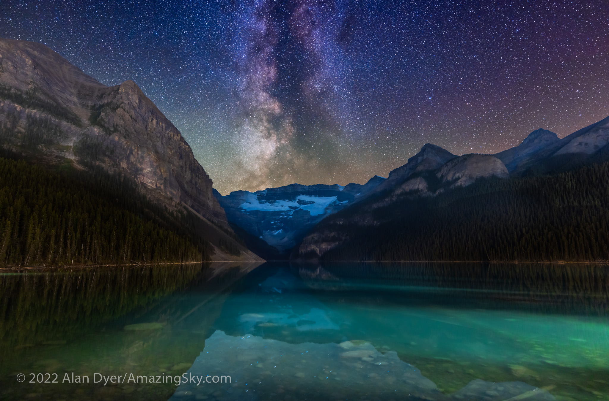
There’s no more famous view than this one, with Victoria Glacier at the end of the blue-green glacial lake. Again, by day the site is thronged with people and the parking lot full by early morning. 

By night, there were just a handful of other photographers on the lakeshore, and the parking lot was nearly empty. I could park right by the walkway up to the lake. 

The Photographer’s Ephemeris
TPE 3D

Again, TPE and TPE 3D told me when the Milky Way would be well-positioned over the lake and glacier, so I could complete the untracked ground shots first, to be ready to shoot the tracked sky segments by the time the Milky Way had turned into place over the glacier. 

This is a blend of three vertical panoramas: the first is a set of three untracked 2-minute exposures for the ground at ISO 800 with the camera moved up by 15° from segment to segment; the second shot immediately afterward is made of 7 x 1-minute tracked exposures at ISO 1600 for the sky, also moved 15° vertically from segment to segment; elements of a third 3-section panorama taken about 90 minutes earlier during “blue hour” were blended in at a low level to provide better lighting on the distant peaks. All with the Canon RF15-35mm lens at f/2.8 and 20mm and Canon R5.

This image is also a panorama but a vertical one, made primarily of three untracked segments for the ground and seven tracked segments for the sky, panning up from the horizon to past the zenith overhead, taking in most of the summer and autumn Milky Way from Serpens up to Cassiopeia.


Nightscape Gear 

As readers always want to know what gear I used, I shot all images on all nights with the 45-megapixel Canon R5 camera and Canon RF15-35mm lens, with exposures of typically 1 to 3 minutes each at ISOs of 800 to 1600. I had other cameras and lenses with me but never used them. 

The R5 works very well for nightscapes, despite its small pixels. See my review of it here on my blog, and of a holy trinity of Canon RF lenses including the RF15-35mm here

Star Adventurer Mini tracker with Alyn Wallace V-Plate and AcraTech Panorama Head

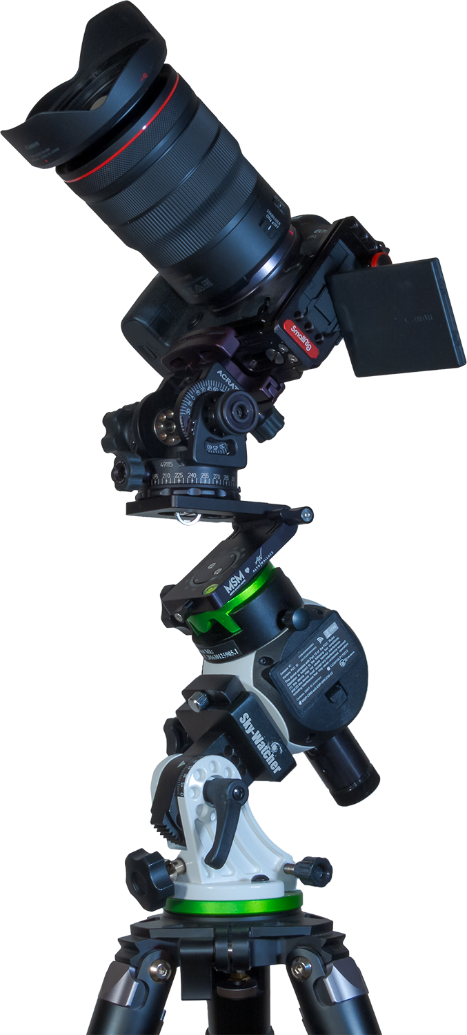
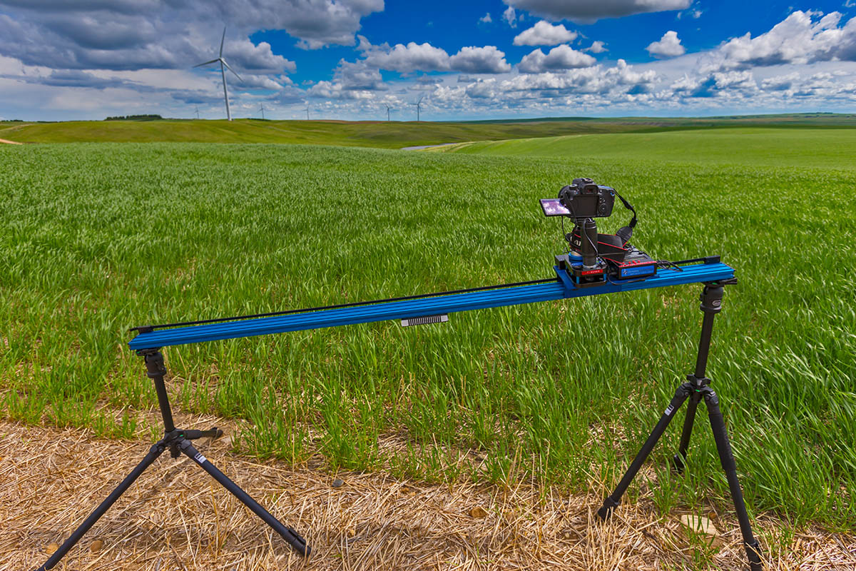
For a tracker for such images, I used the Sky-Watcher Star Adventurer Mini, a compact and lightweight unit that is easy to pack and carry to shooting sites. See my review of it here at AstroGearToday. 

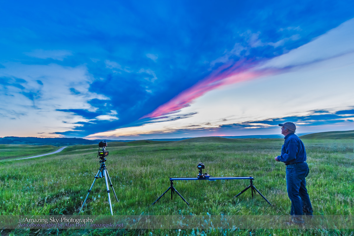
I use the Mini with a V-Plate designed by nightscape photographer Alyn Wallace and sold by Move-Shoot-Move. It is an essential aid to taking tracked panoramas, as it allows me to turn the camera horizontally manually from one pan segment to the next while the camera is tracking the stars. It’s easy to switch the tracker on (for the sky) and off (for the ground). The Mini tracks quite accurately and reliably. Turn it on and you can be sure it is tracking. 

For more tips on shooting panoramas, see my blog post from 2019.


Behind-the-Scenes Processing

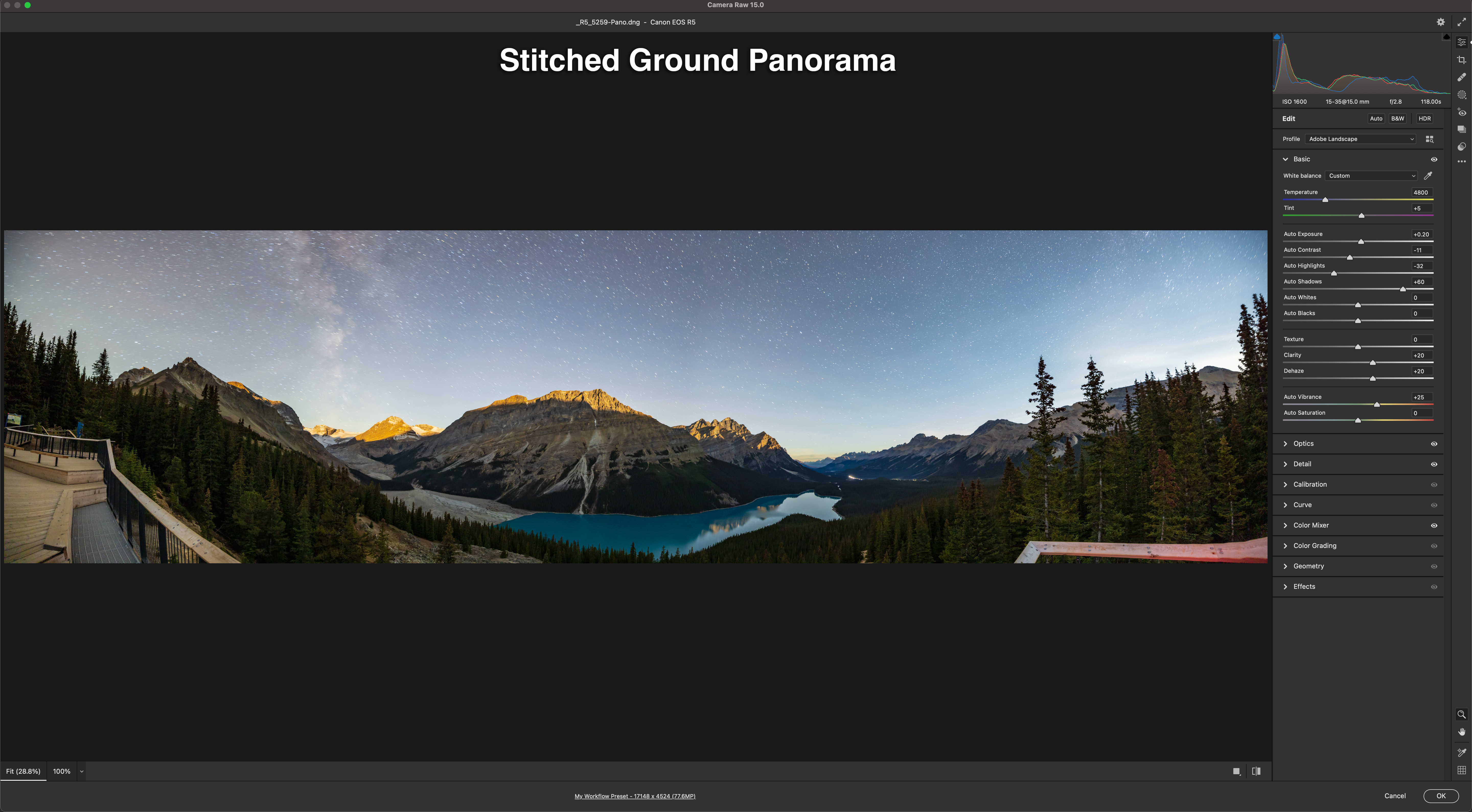
For those who are interested, here’s a look at how I processed and assembled the images, using the Peyto Lake panorama as an example. This is not a thorough tutorial, but shows the main steps involved. Tap or click on an image to download a full-size version.

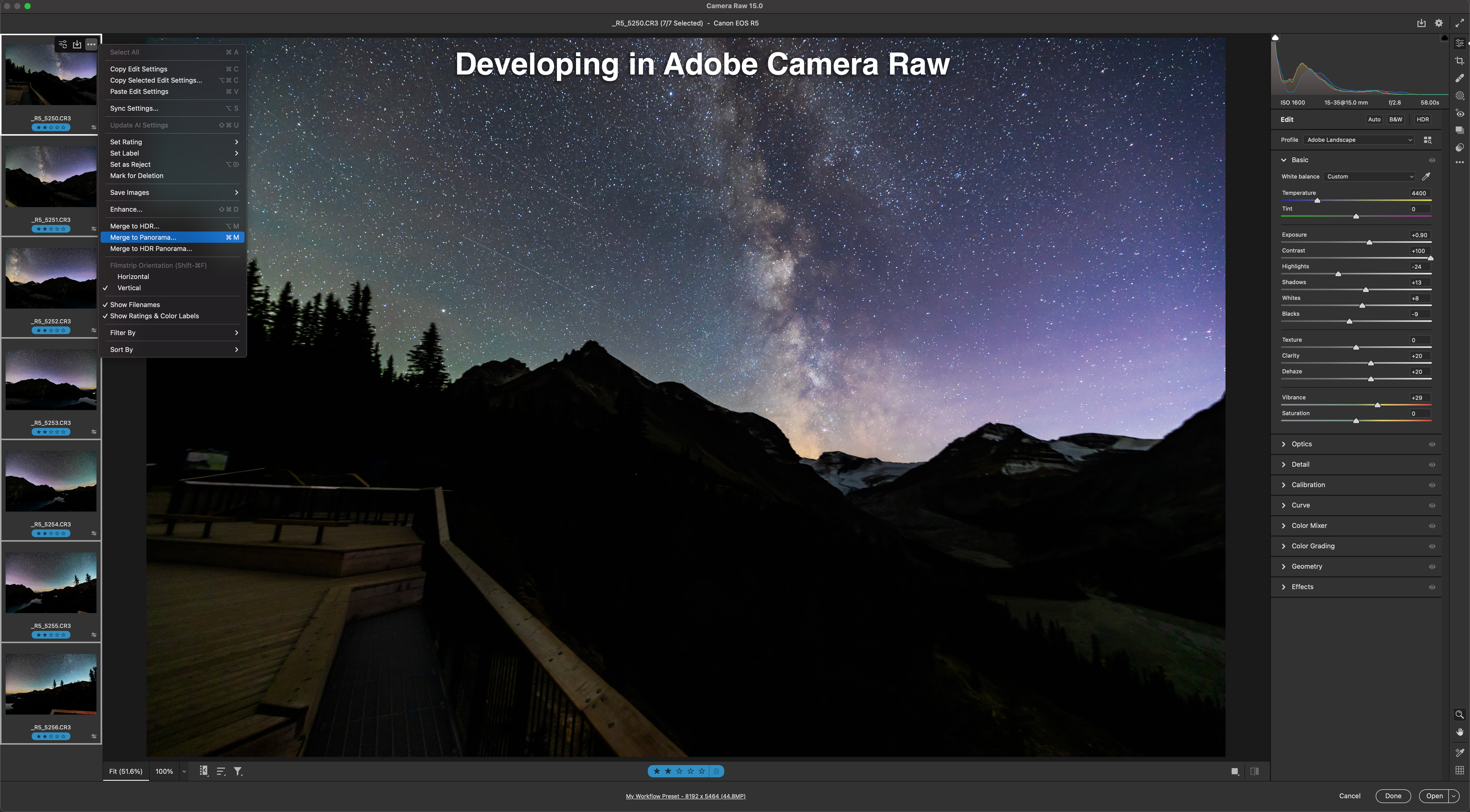
  • I first develop all the raw files (seven here) in Adobe Camera Raw, applying identical settings to make them look best for what they are going to contribute to the final blend, in this case, for the tracked sky with pinpoint stars and the Milky Way. 
  • Camera Raw (as does Adobe’s Lightroom) has an excellent Merge to Panorama function which usually works very well on such scenes. This shows the stitched sky panorama, created with one click.
  • I develop and stitch the untracked ground segments to look their best for revealing details in the landscape, overexposing the sky in the process. Stars are also trailed, from the long exposures needed for the dark ground. No matter – these will be masked out.
  • This shows the stack of images now in Adobe Photoshop, but here revealing just the layer for the sky panorama and its associated adjustment layers to further tweak color and contrast. I often add noise reduction as a non-destructive “smart filter” applied to the “smart object” image layer. See my review of noise reduction programs here
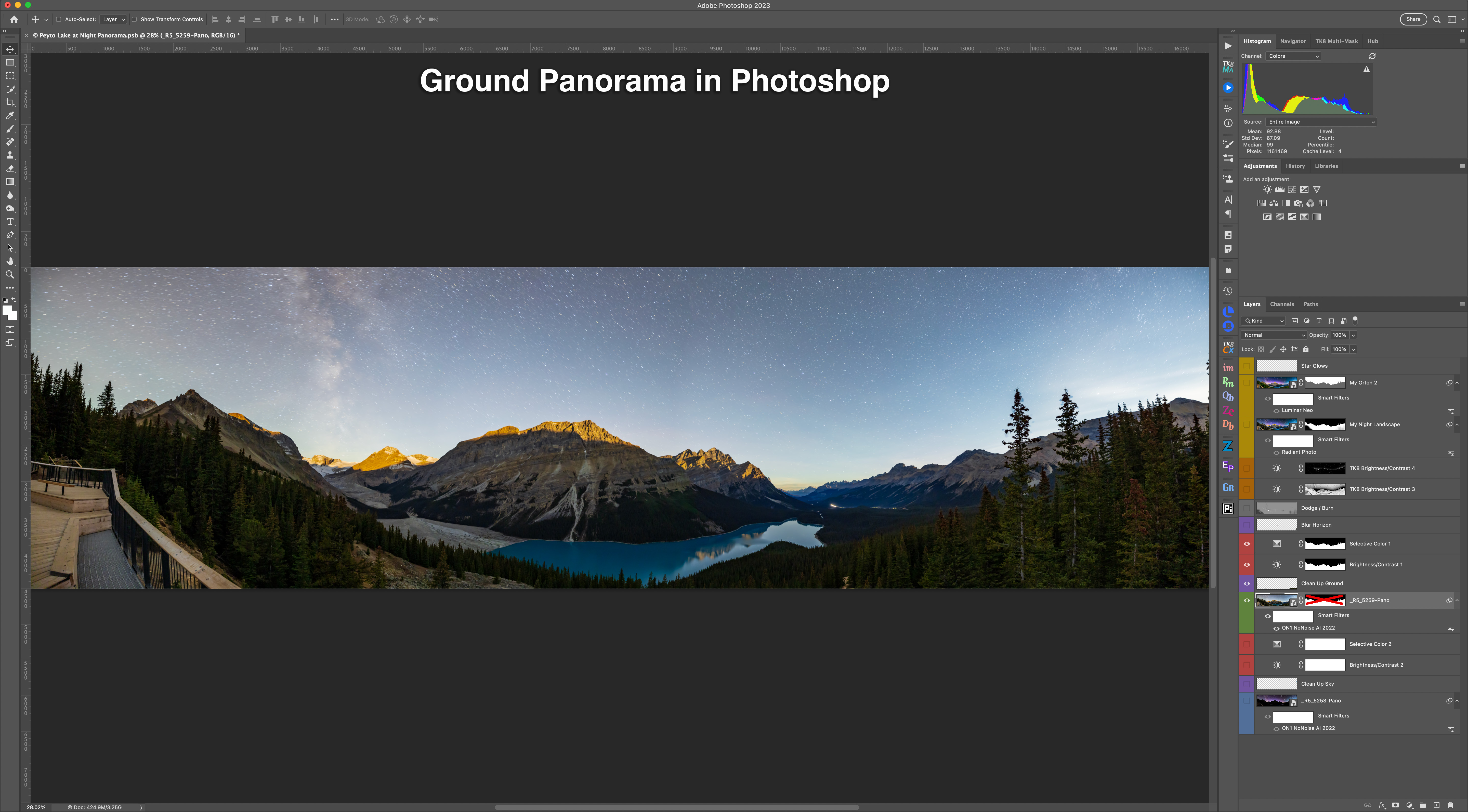
  • This shows just the ground panorama layer, again with some adjustment and retouching layers dedicated to this portion of the image. 
  • The sky has to be masked out of the ground panorama, to reveal the sky below. The Select Sky command in Photoshop usually works well, or I just use the Quick Selection tool and then Select and Mask to refine the edge. That method can be more accurate. 
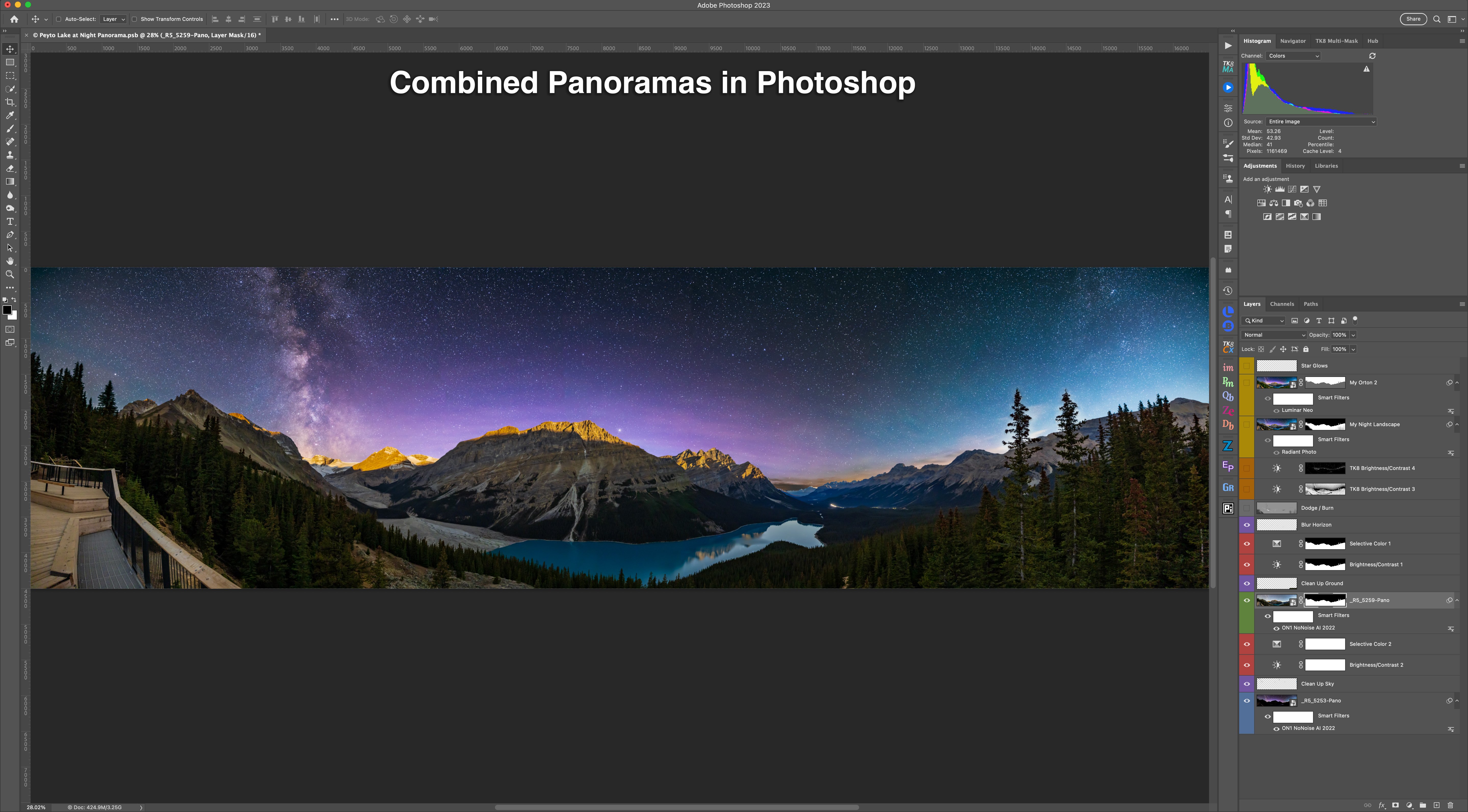
  • Aligning the two panoramas requires manually nudging the untracked ground, up in this case, to hide the blurred and dark horizon from the tracked sky panorama. Yes, we move the earth! The sky usually also requires some re-touching to clone out blurred horizon bits sticking up. Dealing with trees can be a bit messy! 

The result is the scene above with both panorama layers and the masks turned on. While this now looks almost complete, we’re not done yet. 

  • Local adjustments like Dodge and Burn (using a neutral grey layer with a Soft Light blend mode) and some luminosity masks tweak the brightness of portions of the scene for subtle improvements, to emphasize some areas while darkening others. It’s what film photographers did in the darkroom by waving physical dodging and burning tools under the enlarger. 
  • I add finishing touches with some effect plug-ins: Radiant Photo added some pop to the ground, while Luminar Neo added a soft “Orton glow” effect to the sky and slightly to the ground. 

All the adjustments, filters, and effects are non-destructive so they can be re-adjusted later, when upon further inspection with fresh eyes I realize something needs work.  


Was It Photoshopped?

I hope my look behind the curtains was of interest. While these types of nightscapes taken with a tracker, and especially multi-segment panoramas, do produce dramatic images, they do require a lot of processing at the computer. 

Was it “photoshopped?” Yes. Was it faked? No. The sky really was there over the scene you see in the image. However, the long exposures of the camera do reveal more details than the eye alone can see at night — that is the essence of astrophotography. 

My one concession to warping reality is in the time-blending — the merging of panoramas taken 30 minutes to an hour apart. I’ll admit that does push my limits for preferring to record real scenes, and not fabricate them (i.e. “photoshop” them in common parlance).

But at this shoot on these marvelous nights, making use of the perfectly timed moonrises was hard to resist!

— Alan, November 17, 2022 / AmazingSky.com 

The Night-Shadowed Prairie


The Night Shadowed Prairie

“No ocean of water in the world can vie with its gorgeous sunsets; no solitude can equal the loneliness of a night-shadowed prairie.” – William Butler, 1873

In the 1870s, just before the coming of the railway and European settlement, English adventurer William Butler trekked the Canadian prairies, knowing what he called “The Great Lone Land” was soon to disappear as a remote and unsettled territory.

The quote from his book is on a plaque at the site where I took the lead image, Sunset Point at Writing-on-Stone Provincial Park.

The night was near perfect, with the Milky Way standing out down to the southern horizon and the Sweetgrass Hills of Montana. Below, the Milk River winds through the sandstone rock formations sacred to the Blackfoot First Nations.

The next night (last night, July 26, as I write this) I was at another unique site in southern Alberta, Red Rock Coulee Natural Area. The sky presented one of Butler’s unmatched prairie sunsets.

Big Sky Sunset at Red Rock Coulee

This is “big sky” country, and this week is putting on a great show with a succession of clear and mild nights under a heat wave.

Waxing Crescent Moon at Red Rock Coulee

The waxing crescent Moon adds to the western sky and the sunsets. But it sets early enough to leave the sky dark for the Milky Way to shine to the south.

The Milky Way at Red Rock Coulee

This was the Milky Way on Wednesday night, July 27, over Red Rock Coulee. Sagittarius and the centre of the Galaxy lie above the horizon. At right, Saturn shines amid the dark lanes of the Dark Horse in the Milky Way.

I’m just halfway through my week-long photo tour of several favourite sites in this Great Lone Land. Next, is Cypress Hills and the Reesor Ranch.

— Alan, July 27, 2017 / © 2017 Alan Dyer / amazingsky.com


Rising of the “Strawberry” Moon


The Rising Strawberry Moon of June 9, 2017 (Composite)

The Full Moon of June rose into a twilight sky over a prairie pond. 

On June 9, the clouds cleared to present an ideal sky for capturing the rising of the so-called “Strawberry Moon,” the popular name for the Full Moon of June.

The lead image is a composite of 15 frames, taken at roughly 2.5-minute intervals and stacked in Photoshop with the Lighten blend mode.

The image below is a single frame.

The Rising Strawberry Moon of June 9, 2017
The rising Full Moon of June, dubbed the “Strawberry Moon” in the media, as seen rising over a prairie pond in southern Alberta, on June 9, 2017. This is a single exposure stack, from a time-lapse sequence of 1100 frames, with images taken at two second intervals. Shot with the Canon 6D and 200mm lens.
I set up beside a small local prairie pond, to shoot the moonrise over the water. Ducks enjoyed the view and a muskrat swam by at one point.

I shot over 1100 frames, at two-second intervals to create a time-lapse of the rising Moon, as it brightened and turned from yellow-orange (not quite strawberry pink) to a bright white.

Here’s the time-lapse vignette.

Click on HD for the best view.

While the Harvest Moon gets lots of PR, as this sequence shows any Full Moon can provide a fine sight, and look yellow, due to absorption of the blue wavelengths by the atmosphere as the Moon rises, or as it sets.

However, the timing can vary from Full Moon to Full Moon. This one was ideal, with it rising right at sunset. If the Moon comes up too late, the sky might have already darkened, producing too great a difference in brightness between the Moon and background sky to be photogenic.

But what of these Moon names? How authentic are they? 

Who called this the Strawberry Moon? Native Americans? No. Or at best only one or two nations. 

Check the site at Western Washington University at http://www.wwu.edu/depts/skywise/indianmoons.html and you’ll see there were an enormous number of names in use, assuming even this listing is authentic. 

The names like “Strawberry Moon” that are popularized in the media today come from the American Farmers Almanac, and everyone – science writers and bloggers – ends up copying and pasting the same wrong, or at best misleading, information from the Almanac. 

Search for “Strawberry Moon” or “Moon names” and you’ll find the same explanation repeated verbatim and unquestioned by many writers. Alas, the Almanac is not an authoritative source – after all, they were the source of a misleading definition of Blue Moon decades ago. 

Yes, people around the world may have long had names for months and moons, but they were not necessarily the ones that make the rounds of news sites and blogs today. Most are a modern media concoction. A few years ago, pre-internet, no one knew about nor used these names. 
— Alan, June 10, 2017 / © 2017 Alan Dyer / www.amazingsky.com

The Austral Moon of Evening


Waxing Moon in Evening Twilight Colours

From the southern hemisphere the Moon appears “upside-down” and higher each night in the northern sky as it waxes from crescent to Full.

These are scenes from the last week as the Moon rose higher into the evening sky as seen from Australia.

A northerner familiar with the sky would look at these and think these are images of the waning Moon at dawn in the eastern sky.

Waxing Crescent Moon at Cape Conran
The “upside-down” waxing crescent Moon in the evening sky from Victoria, Australia, at Cape Conran, West Cape area, on the Gippsland Coast, at latitude 37° South. Earthshine lights the dark side of the Moon. This was March 31, 2017. The Moon lights a glitter path on the water. This is a single 1.3-second exposure at f/2 with the 85mm Rokinon lens, and Canon 5D MkII at ISO 400.

But no, these are of the waxing Moon (the phases from New to Full) with the Moon in the evening sky.

From the southern hemisphere the ecliptic – the path of the planets – and the path of the Moon arcs across the northern sky. So as the Moon waxes from New to Full phase it appears to the right of the Sun, which still sets in the west. The world still spins the same way down under!

So the Moon appears upside down and with the crescent phase the “wrong” way for us northerners.

Panorama of the Waxing Moon at Sunset at Welshpool Harbour
A 240° panorama from 16 segments.

This panorama taken April 4 sweeps from northwest to southeast, but looks north at centre, to capture the scene at sunset of the waxing 8-day gibbous Moon in the northern sky as seen from the southern hemisphere.

The angle between the Sun and Moon is just over 90°, shown here by the angle between the right-angle arms of the wharf, pointed to the west at left, to the north at centre, and to the east at right.

The Sun has set just north of west, while the Moon sits 13° east of due north. The Earth’s shadow rises as the blue arc at far right to the east opposite the Sun.

Philip Island Sunset and Waxing Moon Panorama
A 240° panorama from 15 segments.

The next night, April 5, I shot this panorama from Philip Island south of Melbourne. Again, it shows the waxing gibbous Moon in the north far to the right of the setting Sun in the west (at left).

Getting used to the motion of the Sun and Moon across the northern sky, and the Moon appearing on the other side of the Sun than we are used to, is one of the challenges of getting to know the southern sky.

Things just don’t appear where nor move as you expect them to. But that’s one of the great delights of southern star gazing.

— Alan, April 8, 2017 / © 2017 Alan Dyer / www.amazingsky.com


Arch of the Sky Above and Land Below


Harvest Moon Rising over the Red Deer River

On Friday night the Harvest Moon rose amid the arching shadow of the Earth.

This was the view on Friday, September 16 at moonrise on the Red Deer River. The view is from the Orkney Viewpoint overlooking the Badlands and sweeping curve of the river.

Above is the wide arch of the dark shadow of the Earth rising into the deepening twilight. Almost dead centre in the shadow is the Full Moon, the annual Harvest Moon.

Hours earlier the Moon passed through the shadow of our planet out at the Moon’s distance from Earth, creating a minor penumbral eclipse. No part of that eclipse, such as it was anyway, was visible from here.

But the alignment did place the Moon in the middle of our planet’s shadow projected into our atmosphere, as it does at every sunset and sunrise.

But it takes a very clear sky for the shadow to stand out as well as this in the darkening sky. I like how the curve of the shadow mirrors the curve of the river.

This is a marvellous spot for photography. I shared the site with one other photographer, at far right, who also came to capture the rising of the Harvest Moon.

The image is a 7-segment panorama with a 20mm lens, stitched with Adobe Camera Raw.

— Alan, September 17, 2016 / © 2016 Alan Dyer / AmazingSky.com

TWAN-black


Waterton Lakes in the Twilight


The waxing gibbous Moon over Upper Waterton Lake in Waterton Lakes National Park, Alberta with the iconic Prince of Wales Hotel in the distance, on a calm evening with still waters, rare in Waterton. This is an HDR stack of 3 exposures with the Canon 60Da and 16-35mm lens, shot from Driftwood Beach.

Happy Canada Day! From one of the most scenic places in the country.

I spent a wonderful four days and nights last week at Waterton Lakes National Park, Alberta, with near perfect weather conditions.

For one, the infamous winds of Waterton weren’t blowing, allowing me to shoot the iconic Prince of Wales Hotel reflected in the calm waters of Middle Waterton Lake at Driftwood Beach, with the waxing Moon above in the twilight sky.

Earlier in the evening, I was at the Maskinonge Overlook shooting some video for upcoming tutorials. At sunset I shot this image, below, of the Moon above the alpenglow of the last rays of sunlight.

The rising waxing gibbous Moon in the sunset sky over Maskinonge Wetlands at Waterton Lakes National Park, Alberta, June 2015. The last rays of sunset are illuminating the peaks in alpen glow. This is an HDR stack of 3 exposures with the Canon 60Da and 16-35mm lens.

Happy Canada Day!

And don’t forget to look west for the ongoing Venus-Jupiter conjunction. I missed the best night last night, June 30 – clouds! But here’s hoping for tonight.

– Alan, July 1, 2015 / © 2015 Alan Dyer / www.amazingsky.com


Copper Moon over a Copper Mine


Copper Moon over Copper Mine

A coppery Moon rises over the Santa Rita Copper Mine. 

The March 5 Full Moon was the smallest Full Moon of 2015, the “apogee” Moon. Or call it the March mini-Moon.

I captured it rising over the vast Santa Rita Mine, east of Silver City, New Mexico, my winter home this year. The Santa Rita mine is one of the oldest continuously operating mines in western North America. I shot the scene from a viewpoint west of the city, using a 135mm telephoto lens.

The image is a composite stack of two exposures taken moments apart: a long 1-second exposure for the sky and ground (but with the Moon overexposed) and a short 1/13-second exposure for the lunar disk to retain details in the disk, like the lunar mare, marking the face of the “man in the Moon.”

The March Mini-Moon

Later in the evening I used my telescope to shoot a close-up of the apogee Moon. I shot a single exposure but processed it with exaggerated vibrance, saturation and contrast to bring out the subtle colour differences in the lunar mare. You can see that some are much bluer than others, due to the higher level of titanium in the lava flows that formed these mare.

As I explained in my previous blog, in seven months the Full Moon will be at the close perigee point in the Moon’s orbit, giving us the closest Full Moon of 2015. That’s also the night of a total eclipse of the Moon. I’ll try to shoot the Full Moon with the same telescope to create a big and small Moon comparison pair.

– Alan, March 5, 2015 / © 2015 Alan Dyer / www.amazingsky.com

Free Sky Calendar for a Starry New Year


Sky Calendar Front Page

As a special New Year’s gift I have prepared a free Calendar of celestial events for 2015.

I have lots of photos and I maintain a personal calendar to remind me of the year’s astronomical events. So why not combine them into a pictorial sky calendar anyone can use!

So I’ve prepared a free 2015 Sky Calendar as a PDF you can download.

To get it, please visit my website page at http://www.amazingsky.com/about-alan.html and scroll to the bottom of the page for a link. It’s a 5 meg download.

The sky events listed are for North America. While most will be visible around the world the timing may be off for other locations. Many thanks for visiting and following my blog this past year. I wish everyone a happy and celestial 2015.

– Alan, December 29, 2014 / © 2014 Alan Dyer / www.amazingsky.com 

New Mexico Moonrise


Moonrise at City of Rocks Panorama

The Full Moon rises with the blue arc of Earth’s shadow over a New Mexico landscape.

I’m now in New Mexico for the winter, enjoying the clear skies and mild temperatures. After a few days of settling into the winter home, tonight was my first venture out to take advantage of the skies and shoot some images.

Tonight was Full Moon, a month after the total lunar eclipse. I drove out to the City of Rocks State Park to capture the moonrise over the unique desert landscape.

The main image above captures the Full Moon sitting amid the dark blue arc of Earth’s shadow rising in the east projected onto Earth’s atmosphere. It is rimmed above with a pink band, the “Belt of Venus,” caused by red sunlight still illuminating the high atmosphere. The image is a 5-section panorama.

In the clear air of New Mexico the shadow and Belt of Venus really stand out.

Moonrise at City of Rocks

A few minutes later, with the Moon higher and sky darker, I trekked amid the unusual rock formations of the Park, to shoot the Moon amid an alien lunar landscape.

These two images are both “high dynamic range” stacks of 7 to 8 images, from short to long exposures, to capture the wide range of brightness in a twilight scene, from the dark foreground to the bright Moon.

Full Moon at City of Rocks

I’m looking forward to a productive winter, photographing the sky and writing about photo techniques, rather than shovelling snow!

– Alan, November 6, 2014 / © 2014 Alan Dyer

Open Road, Open Sky


Open Road and Open Sky

A desert highway leads off into an open blue sky with the waxing Moon.

This week I’m on the road heading south for the winter. Today, I was on US 89, one of the most spectacular roads on the continent, passing through southern Utah and northern Arizona.

At left are the Vermilion Cliffs in Arizona, contrasting with the blue sky and the quarter Moon rising in the east at right.

Waxing Moon over Vermilion Cliffs

I took this view minutes earlier, from a viewpoint above the desert as US 89 descends from the Kaibab Plateau and the area around the North Rim of the Grand Canyon.

I have not driven through this area of the U.S. Southwest in 20 years. I’ll be back through here in spring, when I hope to shoot the April 4 total lunar eclipse from the Four Corners area.

– Alan, October 30, 2014 / © 2014 Alan Dyer

Pre-Eclipse Day in Jasper


Sunbeams over Athabasca Pass

It’s the day before the eclipse, and the skies are not clear!

On Thursday, October 23 the Moon covers the Sun in a substantial partial eclipse. I’m in Jasper National Park, participating in the Park’s annual Dark Sky Festival.

One of the events is a public viewing session of the solar eclipse. Let’s hope for some clearing skies and breaks in the clouds, so we can see 66% of the Sun eaten by the Moon!

I shot this image at eclipse time the day before – today! – from a viewpoint looking west toward the Sun on the Icefields Parkway south of Jasper townsite.

David Thompson Sign at Athabasca Pass Overlook

The Sun is trying to break through and is casting its beams down onto the famed Athabasca Pass, the route over the mountains pioneered by David Thompson in the early 1800s when his preferred route over Howse Pass to the south was blocked by the Pikanii who objected to Thompson trading with their enemies over the Rockies.

I show the area of Howse Pass in this previous big post from earlier this summer

Thompson was one of the first astronomers in western Canada, using the Sun, Moon, Jupiter and stars to navigate his way and map the country. The lower sign explains. Click on the image for a larger view.

The Dark Sky Festival continues the tradition of stargazing in Jasper, a science Thompson depended upon in his travels.

– Alan, October 22, 2014 / © 2014 Alan Dyer

Stars on Ice – The Columbia Icefields by Moonlight


Star Trails over Columbia Icefields

The stars trail over the glaciers of the Columbia Icefields.

What an amazing night this was! You rarely get pristine cloudless skies over the Icefields. Some cloud is almost always blowing off the ice. But last Saturday in Jasper National Park was as clear as it gets.

The Moon was bright, as a waxing gibbous just off frame at left. It lit the landscape like it was day.

I shot with two cameras, one doing a time-lapse motion control sequence panning across the scene. The other was a fixed camera shooting 20-second exposures at 1-second intervals. The resulting frames from the fixed camera, 270 in this case, are multi-purpose:

– I stacked about 100 of them to make the star trail composite above. Two frames supplied the stars at the beginning and end of the trails. Another single frame supplied the ground, to avoid the shadows being blurred by the Moon’s motion if you used the ground composited from all 100 frames.

– I can also take the full set of 270 frames and sequence them into a time-lapse movie of the stars moving over the landscape.

Stars over the Columbia Icefields Panorama

Before beginning the time-lapse sequences I shot this 180° panorama, made of 5 segments stitched in PTGui software. It extends from the southwest at left, where the Milky Way is barely visible, to the north at right, with the Big Dipper over the Icefields Parkway.

Click on it for a bigger view.

Shooting at the Icefields

This is the camera setup, with the camera on the right taking the star trail image I feature at top.

The Athabasca Glacier is at left, the Stutfield Glacier at right.

Icefields Parking Lot at Night

Midnight under moonlight is when to see the Icefields! This is the lower parking lot, at the start of the trail up to Athabasca Glacier. This is packed with cars, RVs and buses by day, but at night I was the only one there.

– Alan, Sept, 8, 2014 / © 2014 Alan Dyer


Sunset over David Thompson Country


Howse Pass Viewpoint Panorama (Partial)

The setting sun lights the clouds over the river plains of the North Saskatchewan.

This was the panoramic view two evenings ago from the Howse Pass viewpoint on the Icefields Parkway in Banff.

We’re looking south over the North Saskatchewan River near its junction with the Howse and Mistaya Rivers. The spot is near where Highway 11, the David Thompson Highway, comes in from the east to join the Parkway. It’s a modern highway now but 200 years ago this was a main canoe route for the fur trade.

The area is known as David Thompson Country, named for the great explorer, surveyor, and celestial navigator who mapped much of western Canada in the early 1800s.

Until about 1810, Thompson passed this way every year en route to the fur trade forts he set up in the B.C. interior, his main job for the North West Company.

Conflicts with the local Pikanii people, who objected to Thompson trading with and arming their traditional enemies, the Kootenais, forced Thompson to find a new route across the Rockies, the Athabasca Pass in what is now Jasper National Park.

Howse Pass Viewpoint Sunset Panorama (Full)

The top image is a 180° panorama, the bottom image is a full 360° panorama from the viewpoint. In the distance are Mt. Murchison, at left, and Mt. Cephren in the far distance, the prominent peak by Waterfowl Lakes.

I shot these with a 14mm lens, in portrait orientation, and stitched them with PTGui software. The top image is made from 6 segments, the bottom from 12 segments.

The software blended them perfectly, no small feat in such a uniform twilight sky. I’m always impressed with it!

– Alan, August 14, 2014 / © 2014 Alan Dyer


Rainbow at Blackfoot Crossing


Rainbow at Blackfoot Crossing #2

A low rainbow shines beneath a retreating thunderstorm at Blackfoot Crossing Historical Park.

On my way home from Waterton Lakes I drove through a thunderstorm, then watched it retreat and the Sun break through in the west. I was hoping for a rainbow in the east, and sure enough, one appeared.

With the Sun still high in the late afternoon sky, the rainbow was low, with just a small arc appearing above the horizon.

By good luck, I was passing the hilltop Blackfoot Crossing Historical Park, a beautiful museum interpreting the history of the Siksika Nation, and a great place to look out over the prairie.

These photos look down a line of rock cairns running from the interpretive centre to the hilltop cemetery in the distance, below the arc of the bow.

Rainbow at Blackfoot Crossing #1

This wider angle image gives the context, with the bow at the bottom of the thundercloud, and fresh blue sky above.

I love the mountains but it’s nice to be back home on the prairies where we can see the wide horizon.

– Alan, July 20, 2014 / © 2014 Alan Dyer

Wild Rose Twilight at Red Rock Canyon


Waterton Wild Rose Twilight

Evening light illuminates the peaks around Red Rock Canyon in Waterton Lakes National Park.

I took this image last evening as part of a time-lapse sequence, framing the wild roses in the foreground and the peaks of Mount Blakiston (at left) and Mount Anderson (at right) in the distance. The site is the popular Red Rock Canyon area of the Park.

The last rays of sunlight are hitting Blakiston.

That peak is named for Thomas Blakiston, the first scientific explorer to map the area of Waterton and the passes of the southern Canadian Rockies. Although at the time he was here in 1858, this was still British colonial territory separated from the United States by an ill-defined border running along the 49th parallel just south of this spot.

Blakiston was part of the British Palliser Expedition, led by John Palliser, whose mission was to survey the little-known region south of the South Saskatchewan River to assess its suitability for settlement.

Palliser concluded that the parched rain-shadow area of what is now southern Saskatchewan and Alberta was “desert, or semi-desert in character, which can never be expected to become occupied by settlers.” That area became known as the Palliser Triangle. Only extensive irrigation made settlement possible.

Blakiston was the expedition’s magnetical observer, taking readings of the Earth’s magnetic field strength and direction throughout the region. He disputed Palliser’s leadership and soon broke away from the expedition to conduct his own treks and compile his own reports. It was Blakiston who named the area after Charles Waterton, a famous British naturalist of the time. The region became a nationally-recognized park in 1895

— Alan, July 18, 2014 / © 2014 Alan Dyer


Sunset over Waterton Lakes


Waterton Lakes Sunset

The setting Sun lights the clouds over Upper Waterton Lake, Alberta.

Waterton Lakes National Park is certainly one of my favourite places. The scenery is wonderful and the town small and quiet. It has all the beauty of Banff with none of the retail sprawl and traffic jams.

I shot the scene above two evenings ago, July 15, from the viewpoint at the Prince of Wales Hotel. It overlooks Middle and Upper Waterton Lakes, the latter lighting up as it reflects the sunset clouds. This is a frame from a motion-control time-lapse.

Waterton Lakes Trees

Last night I shot a time-lapse from the lakeshore, looking through the windswept trees toward the south end of the Upper Lake, as the Milky Way begins to appear in the darkening twilight.

Lights from the campground illuminate the trees with just enough light to balance the foreground and sky. Sometimes you can make use of man-made light.

I’m here at Waterton to conduct some public programs Friday and Saturday night. Skies are clear but hazy with smoke and cirrus clouds. But the days and nights are warm and aren’t windy, a welcome treat in Waterton!

– Alan, July 17, 2014 / © 2014 Alan Dyer


Sunset over the Lonely Log Cabin


Log Cabin at Sunset

The clouds paint the sky at sunset over a pioneer cabin in the Cypress Hills.

This is a scene the original resident of this cabin would have enjoyed – and painted.

This lonely log cabin in the Battle Creek valley was built by Robert David Symons, renowned as a rancher, naturalist, game warden, and painter, in the style of western artists such as Charlie Russell.

The cabin looks like it dates from the pioneer days of the first European settlement of the area, in the late 19th century. But Symons settled here and built this log cabin in 1939, during the time he worked as a game warden in the Hills, posted at the Battle Creek Ranger Station. He lived in the cabin for only three years before selling it to Albert and Sylvia Noble in 1942.

The Nobles expanded the cabin to accommodate their family. They lived here for 10 years, working a sawmill in the area.

Today the cabin is a scenic stop on the rough and often muddy Battle Creek Road that winds from the Alberta to the Saskatchewan side of Cypress Hills Interprovincial Park. Travelling it is like being back in the 1940s, when roads were no better than improved cart tracks.

Shooting Time-Lapses at Cypress Hills Log Cabin

I spent an evening here two nights ago on a perfect summer night, shooting the sunset and then the cabin scene by moonlight using time-lapse cameras and gear.

The main scene at top is a high dynamic range stack of 6 images to preserve details in the bright sky and dark foreground.

The self-portrait is a single shot taken by moonlight. Mars and Spica are just setting as a pair of stars over the hills across the valley.

It was a magical night in the Hills.

– Alan, July 11, 2014 / © 2014 Alan Dyer


Wild Rose Sunset


Wild Rose Sunset

The sky lights up pink to match the wild roses in Cypress Hills.

Last night the twilight sky over the Cypress Hills was simply stunning. The clouds contrasted with the blues and pinks of twilight. On the way out to an evening shoot I stopped to take this image of the darkening sky colours behind the blooming wild roses, the floral emblem of Alberta.

In this photograph I’m looking east, opposite the sunset. The dark blue on the horizon is the shadow of the Earth rising. Above the shadow is a fringe of pink, the Belt of Venus, from red sunlight still lighting the upper atmosphere in that direction. Its colour nicely matches the pink roses – Earth and sky in colour coordination.

This is a high dynamic range stack of 6 exposures, to capture the bright sky and darker foreground in one image, to render the scene as the eye saw it but the camera could not, at least not with a single exposure.

– Alan, July 8, 2014 / © 2014 Alan Dyer


Sunset on the Range


Sunset on the Range

The setting Sun provided a fine light show on the open range of the Canadian Prairies.

This was the scene Friday evening, July 4, as the Sun lit up the clouds in the big sky of the Historic Reesor Ranch.

I’m here for a week of intensive shooting and writing. On the first night the setting Sun put on a fine show, captured in still images, like the high dynamic range composite above, and in time-lapses captured with the motion control gear below.

Reesor Ranch Sunset Shoot #4

When I took these shots I was likely right on the 105th meridian, the line of longitude that marks the boundary of Alberta and Saskatchewan. Either way, the land is expansive and stunning.

Just to the south the land rises to the Cypress Hills and the namesake provincial park where I’m spending most nights shooting stills and time-lapses. More to come this week I’m sure!

– Alan, July 7, 2014 / © 2014 Alan Dyer


A Windy Day on the Wind Farm


Windfarm Cloudscape

It was windy day out on the wind farm, with some wonderful cloudscapes blowing by.

Shooting time-lapse movies by day is so much easier than shooting at night! Yesterday, to try out some new gear and grab footage for some demo videos, I drove to the nearby Wintering Hills Wind Farm, site of some previous images and movies I’ve posted. It’s a wonderful place for nightscapes, but in this case I shot cloudscapes by day.

The movie compiles five time-lapse clips into a short demo of cloudscapes and time-lapse techniques: using fixed cameras and using cameras on motorized devices that move the camera a little between each time-lapse frame – what’s called “motion control.”

It might take a moment to load and play through. But do expand it to full screen.


For two clips in the movie I used a Dynamic Perception Stage Zero dolly rail, a unit I bought two years ago and have used a lot for time-lapse shooting.

DP Stage Zero Dolly and Stage R on Induros

Here I show it on the new pair of Induro tripods, a much more stable arrangement than the single large tripod I had been using up to now. What’s also new is the Stage R panning unit, now attached to the dolly platform, here on the left (the controller is on the right).

DP Stage Zero Dolly and Stage R CU

What this motorized unit does is allow the camera to slowly turn in azimuth as it is running down the rail, to keep the camera aimed at a foreground subject, or to pan along the horizon, as I do in one of the clips in the movie.

This is a brand new piece of kit, purchased last month through Dynamic Perception’s Kickstarter campaign. I got one of the first batch of units shipped out. It works very well but takes a little practice to get the speeds set right. I’m still working on that!

I hope you enjoy the little demo movie. It shows that even cloudy skies can be photogenic at times!

– Alan, June 29, 2014 / © 2014 Alan Dyer


Rainbow at Sunset


Rainbow over Prairie Field (Wide-Angle)As the setting Sun broke through clouds it created a rainbow over my backyard.

I see lots of fine sky phenomena right from my back deck. Such was the case last evening as a storm retreated east as they typically do. Clearing skies in the west allowed the Sun to shine through, the perfect combination for a rainbow.

For the main image above I shot the double rainbow with the ultra-wide 14mm Rokinon lens …

Rainbow over Prairie Field (Fish-Eye

… and also with the 8mm Sigma fish-eye lens for this image. It’s angled to be suitable for re-projection in a tilt-dome planetarium theatre.

We’re into stormy spring weather here in Alberta, so there will be many more rainbows to follow the dark clouds. Let’s hope for no more floods like last June.

– Alan, June 1, 2014 / © 2014 Alan Dyer


Red Rock Coulee Cloudscapes


Red Rock Coulee Cloudscape Panorama

The strange rock formations of Red Rock Coulee, Alberta lie below the cloudscape of a prairie sky.

Yesterday afternoon I visited the Red Rock Coulee Natural Area, a dramatic but little known geologic wonder in southern Alberta. I was inspecting the site for a possible return one night to shoot time-lapse nightscapes. But while there I took the time to shoot daytime cloudscapes.

The image above is a two-section panorama with an ultra-wide 14mm lens.

Red Rock Coulee Cloudscape #1

This image and the one below are other compositions in this very photogenic spot. In the distance lie the peaks of the Sweetgrass Hills in Montana.

These odd rock formations are sandstone concretions deposited in prehistoric seas and are apparently some of the largest examples of this type of formation in the world. Iron content gives them their red tone.

Red Rock Coulee Cloudscape #2

As a technical note, all the images are high-dynamic range (HDR) stacks of 8 exposures taken over a wide range of shutter speeds to record details in both the bright sky and darker shadows.

I processed them with Photoshop CC’s HDR Pro module and then Adobe Camera Raw in 32-bit mode. I aimed for a more natural look than you see in most HDR images, but even so the cloud contrast is exaggerated for dramatic effect. The wide-angle lens perspective adds to the effect.

This was a wonderful place to stand under the big skies of southern Alberta on a warm spring afternoon.

– Alan, May 25, 2014 / © 2014 Alan Dyer


McDougall Church under Moonlight


McDougall Church in Moonlight #1 (May 14, 2014)

The historic pioneer church at Morley, Alberta stands under moonlight on the banks of the Bow.

Last night, after presenting a talk on time-lapse techniques to the Cochrane Camera Club, I headed west on Highway 1A to the historic McDougall Memorial United Church, long on my target list for time-lapse photography. It was Full Moon, which helped mask the lighting from nearby town lights and the urban sky glow of Cochrane and Calgary.

The wooden church stands on the benchlands north of the Bow River, near Morley, Alberta. Rev. George McDougall built it in 1875 to minister to the Cree. He lies buried on the Church grounds — that’s his grave in the foreground in the main image above, with the Full Moon shining above the headstone.

McDougall Church in Moonlight #2 (May 14, 2014)

In this image, Mars stands directly above the Church steeple. The Full Moon shines in the clouds to the south. Both still images are frames from time-lapse movies, shot with two cameras. One was on the Dynamic Perception Stage Zero dolly, the other was a static tripod-mounted camera.

This little compilation shows the movies I shot last night, under moonlight on the banks of the Bow. It may take a moment to load. I hope you enjoy it!

— Alan, May 15, 2014 / © 2014 Alan Dyer


Sunset at the City of Rocks


Sunset at the City of Rocks (May 2, 2014)

The Sun sets behind the desert landscape of the City of Rocks State Park, New Mexico.

This is another shot from two nights ago, May 2, taken during my evening shoot at New Mexico’s City of Rocks State Park. I took this right at sunset, and you might be able to see the tiny crescent Moon in the twilight sky.

I used an ultra-wide 14mm lens and took a set of 7 exposures taken at 2/3rds stop intervals to capture the full range of brightness from brilliant Sun to shadowy landscape.

I stacked the exposures using Photoshop’s HDR Pro module and then “tone-mapped” the huge range of tonal values using Adobe Camera Raw in its 32 bit mode. This is an excellent way to process “HDR” images, compressing the huge range in brightness into one displayable image. I’ve used several HDR programs in the past but the new method of being able to use ACR, made available in recent updates to Photoshop CC, produces superb natural-looking results. I highly recommended it.

— Alan, May 4, 2014 / © 2014 Alan Dyer


The Pull of the Moon


Moonrise at Woolgoolga, Australia #2

The Full Moon rises over the Pacific Ocean, exerting its pull on the ocean tides.

This was the scene last night, Monday, March 17, 2014 from the headlands at Woolgoolga, New South Wales, Australia. The views overlook the Pacific Ocean with the Full Moon rising. If the Moon looks a little odd, it’s because I took these images from “down under,” where the Moon appears  upside down compared to what we northerners are familiar with.

However, no matter your hemisphere, the Moon exerts a tidal pull on the globe, which manifests itself most obviously as the twice-daily rise and fall of the ocean tides at shorelines like this. When I took these shots at moonrise, the tide was just past its minimum and was beginning to come in again, for a peak later that night with the Moon high in the north.

Moonrise at Woolgoolga, Australia #1

This image was from a few minutes earlier, with the Moon having just risen and looking a little more pale against the darkening twilight of the eastern horizon.

I’m in Australia for the next few weeks, to shoot lots of images of the southern autumn sky, skies permitting.

– Alan, March 18, 2014 / © 2014 Alan Dyer

Waning Moon in the Sunrise Clouds


Waning Moon at Sunrise (Feb 27, 2014)

The thin waning Moon sits in the red clouds of sunrise on a winter morning.

This was the scene this morning, February 27, just before sunrise when I was able to catch the thin crescent Moon – a waning Moon – amid the sunrise clouds. The Moon just happened to appear in a clearer hole in the clouds, in a blue patch above the pinks and oranges of the clouds. They contrast with the cold blue snow below.

This was a beautiful scene to start the day.

– Alan, February 27, 2014 / © 2014 Alan Dyer


Sunset at White Sands


Sunset at White Sands, New Mexico (Dec 10, 2013)

The setting Sun sets the sky on fire above the gypsum dunes of White Sands National Monument.

A week ago I was at Chiricahua National Monument in Arizona for the sunset. This was the scene tonight, at White Sands National Monument in New Mexico.

I was on top of a sand dune at the Yucca picnic area on the Loop Road, watching an amazing sunset over the dunes. The clouds lit up on cue and Venus began to appear, visible here left of centre. The horizon was rimmed with a rainbow of twilight tints.

It was a cool evening, and driving on the unpaved Loop Road graded out of the white sand made me feel I was back home driving on a snow-covered back road. But the white stuff wasn’t snow but pure white gypsum.

This image is a High Dynamic Range (HDR) stack of seven exposures taken at 2/3rd stop increments and composited with Photomatix Pro. The technique brings out details in the shadowy landscape while preserving the bright sky. I used the 14mm Rokinon lens on the Canon 5D MkII. Final processing was in Photoshop CC.

– Alan, December 10, 2013 / © 2013 Alan Dyer


Twilight in the Chiricahuas


Evening Twilight in the Chiricahuas, Arizona (Dec 3, 2013)

The colours of twilight illuminate the eroded rock formations of Chiricahua National Monument in southeast Arizona.

This was the scene tonight, Tuesday, December 3, as night fell over the Chiricahua Mountains in Arizona. The landscape below is a maze of eroded towers of ancient volcanic ash. The sky above is one of the finest on the continent for stargazing.

I spent a week or so here back in May 1995, stargazing with friends from the parking lot at Massai Point at the summit of the Chiricahuas. Tonight was my first visit back to that parking lot in 18 years. The evening was just as windy as I remember it in 1995. And as it was back then, Venus was in the western sky tonight.

Sunset in the Chiricahuas, Arizona (Dec 3, 2013)

This was sunset a few minutes earlier when the clouds were lit red by the setting Sun. I used a 24mm lens for this shot but a 14mm lens for the main image above.

Both shots are 7- to 8-frame “high dynamic range” composites that stack images taken in quick succession over a range of exposures from 2 stops under to 2 stops overexposed. The stack of images, when merged with HDR software, captures what one exposure cannot, due to the huge contrast between the bright sky and the dark foreground at twilight. I used Photomatix Pro software to do the merging and tonal balancing. Such amazing digital tools were unheard of and undreamed of in 1995!

— Alan, December 3, 2013 / © 2013 Alan Dyer

Equinox Highway


Equinox Setting Sun (Sept 23, 2013)

Highway One heads into the setting equinox Sun.

I try for this shot every year, and every year I’m thwarted by low clouds over the Rockies to the west.

So here’s the shot from tonight, Monday, September 23, the night after equinox. Had the horizon been perfectly clear tonight the Sun would have appeared right at the end of the Trans-Canada Highway as it set behind the Rockies. Instead, it disappeared higher up and to the left, behind low cloud.

At equinox (fall or spring) the Sun rises due east and sets due west. So tonight, it was shining into the eyes of all the drivers as they headed west into Calgary – a little demonstration of the annual motion of the Sun.

The previous night, Sunday, Sept. 22, I shot a time-lapse movie of the scene, again hoping for a clear shot to the setting Sun. Alas! A neat movie but still not quite what I was after.

There’s always 2014. But I think I need to aim east and catch the rising Sun at equinox instead. The mountains attract too many clouds.

– Alan, September 23, 2013 / © 2013 Alan Dyer


Harvest Moonrise at Sunset


Harvest Moonrise #2 (Sept 19, 2013)

The Harvest Moon rises with pink hues into the deep blue twilight over prairie fields.

This was the scene tonight, September 19, as the Full Moon rose into a clear eastern sky. The view was perfect, with a cloudless horizon (for a change!) and the Moon prominent and pink as it rose into the twilight sky.

The main image is from a few minutes after moonrise. The bottom image, with a dimmer Moon, is from just after moonrise.

In neither case did I punch up the Moon in contrast or colour separately from the sky to make it stand out more than it did in real life. And I certainly did not paste a telephoto lens shot of the Moon into a wide-angle scene. That’s faking it. This is real.

Harvest Moonrise #1 (Sept 19, 2013)

Both frames are from a 670-frame time-lapse sequence, from the Moon first peaking above the horizon to when it rose out of frame at top right. That’s still in processing!

– Alan, September 19, 2013 / © 2013 Alan Dyer


Harvest Moonset at Sunrise


Harvest Moonset at Dawn (Sept 19, 2013)

The Harvest Full Moon sets into a prairie scene lit by the rising Sun.

This was the scene this morning, September 19, as the Full Moon set just after sunrise on a perfectly clear morning.

Clear, of course, but for the only clouds in the sky just where I wanted to shoot. However, in this case they did help make the scene, adding more colours to the western sky at dawn.

This was the true Harvest Moon, as moonset occurred only a couple of hours after the official moment of Full Moon. However, the setting moons of Wednesday night, September 18 and Thursday night, September 19 can both claim to also be the Harvest Moon, the Full Moon closest to the autumnal equinox.

I plan to shoot the Moon coming up again, 12 hours after it set for this photo, and right at sunset tonight.

– Alan, September 19, 2013 / © 2013 Alan Dyer


Cassiopeia Rising in the Badlands


Cassiopeia Rising Behind Hoodoos (Aug 18, 2013)

The stars of Cassiopeia rise behind hoodoo formations in the Alberta Badlands.

I took this Sunday night, August 18, as part of my shoot at Dinosaur Provincial Park. This is a particularly striking pair of hoodoos at the start of the Badlands Trail where I’ve been meaning to take some moonlit nightscapes for a couple of years.

This night’s conditions were perfect, with the “W” of Cassiopeia nicely placed, and the Moon providing excellent cross-lighting, under a clear blue sky, for the contrasting colours of earth and sky.

– Alan, August 20, 2013 / © 2013 Alan Dyer

Dinosaur Moon


Waxing Moon in Badlands Twilight (August 18, 2013)

The waxing Moon rises into a colourful twilight sky over the badlands of Dinosaur Provincial Park.

What a great night it was last night! Warm summer temperatures (at last!) allowed for shirtsleeve shooting even well after dark. To shoot on the warm August night I went out to Dinosaur Provincial Park, a magical place to be at sunset and in the summer twilight. The colours on the badlands are wonderful. It’s earth-tones galore, with the banded formations from the late Cretaceous blending with the sagebrush and prairie flowers.

This was the scene after sunset, as the waxing Moon rose into the eastern sky coloured by the blue band of Earth’s shadow, the pink Belt of Venus and dark blue streaks of cloud shadows converging to the point opposite the Sun. That’s where the Moon will be Tuesday night when it’s full. But last night it was a little west of the anti-solar point.

Moon and Sunset Glow at Dinosaur Park (August 18, 2013)

I managed to grab this image as soon as I got to my photo spot on the Badlands Trail, just in time to catch the last rays of the setting Sun illuminating the bentonite hills of the Badlands. Both shots are frames from a 450-frame time-lapse, taken with a device that also slowly panned the camera across the scene over the 90-minute shoot.

It, and three other time-lapses I shot after dark, filled up 40 gigabytes of memory cards. It’s been a terabyte summer for sure!

– Alan, August 19, 2013 / © 2013 Alan Dyer


The Great Lone Land … and Great Big Sky


The Gap Road Panorama (Cypress Hills Park)

A vast blue sky and summer storm clouds arch over a prairie landscape.

This is a place where you are out on the vast open plains, looking much as they would have appeared hundreds of years ago. This is big sky country, in southwest Saskatchewan. I shot this 360° panorama last Sunday, on a road I get to take every few years that is one of the great drives in western Canada.

Some years it is too wet and impassable. Other years it is too dry and closed because of the fire hazard.

This is the Gap Road, a mud track at times between the Saskatchewan and Alberta units of Cypress Hills Interprovincial Park. The road crosses private rangeland but the cattle are the only giveaway that this is a modern scene and not one from the 19th century.

In 1872 the British explorer and adventurer William Francis Butler crossed the prairies and northern plains in the last days of the buffalo culture, before the cattle and ranchers arrived. He called it then The Great Lone Land. You feel that sense in a place like this, out on the open treeless plains. 150 years ago great herds of bison roamed here. And it was here that the North West Mounted Police set up their first outpost in the area, at Fort Walsh, to stop the incursions of the American “wolfers.”

The sky dominates the scene. I spent an hour here, shooting a time-lapse of the approaching thunderstorm, at right, coming toward me from miles away, until it filled the sky and threatened to turn the road back into mud.

It was a wonderful day spent crossing the prairies, and traveling back in time.

– Alan, August 16, 2013 / © 2013 Alan Dyer


Wheatfield Moon


Wheatfield Moon (Aug 14, 2013)

The waxing Moon shines above a ripening field of wheat on a prairie August evening.

A track winds off through the wheat field toward the western twilight sky, while a waxing Moon shines in the south.

This was the scene tonight just down the county road where I live, on a warm August night on the Canadian Prairies.

For this shot, I assembled a high dynamic range set from eight exposures taken over a range of 8 f-stops, to compress the wide range of brightness into the one photo. Even so, the Moon remains overexposed. But I like shooting these scenes in deep twilight for more saturated colours and for some stars in the sky.

– Alan, August 14, 2013 / © 2013 Alan Dyer


Canola Field Stars


Circumpolar Star Trails over Canola Field (July 26, 2013)

Stars in a blue sky wheel above a ripening field of yellow canola.

It’s been a couple of fine nights of nightscape shooting under the light of the waning Moon and clear skies.

I’ve been shooting from no more exotic location than my local rural neighbourhood, travelling for 5 minutes to spots near one of the many canola fields growing nearby. I wanted to grab some nightscapes over the  fields before they lose their yellow flowers and turn green.

The feature image above looking north is from a time-lapse sequence and stacks several images with the “comet trail” effect, to show the northern stars turning about the North Star.

Big Dipper over Canola Field #2 (July 26, 2013)

This image, also a frame from another time lapse with a longer lens, shows the Big Dipper above that same field but in an exposure short enough to prevent the stars from trailing. You can now make out the familiar Dipper pattern.

This is a very Canadian scene, with the Big Dipper high in a northern latitude sky, and with the foreground crop a Canadian one – Canola was developed in the 1970s at the University of Manitoba. The “can” in canola stands for Canada. Pity there was no aurora.

– Alan, July 28, 2013 / © 2013 Alan Dyer


Sunset Panorama at Reesor Ranch


Sunset at Reesor Ranch Panorama #1 (July 11, 2013)

The setting Sun lights up a classic Canadian prairie skyscape. 

This was sunset last night, July 11, from the historic Reesor Ranch in southwest Saskatchewan, on the north edge of the Cypress Hills. The clouds opened up across the sky in a Chinook arch, with clearing to the west where the waxing Moon and Venus were also setting into the twilight.

It was a stunning scene looking out over the plains from the highlands of the hills.

I’m in the area for a week of shooting, weather permitting.

This shot is a 7-section panorama, stitched with Photoshop’s Photomerge command.

– Alan, July 12, 2013 / © 2013 Alan Dyer


Low Bow over Canola


Low Rainbow over Canola Field

A horizon-hugging rainbow shines over a blooming field of canola.

You don’t often see a rainbow like this. Just the top of the bow pokes above the horizon and a field of yellow canola.

The reason is the Sun’s altitude. When I shot this in late afternoon yesterday, July 4, the Sun was 40 degrees up in the northwest. That means the point opposite the Sun was 40 degrees below the horizon in the southeast. Rainbows are centred on this anti-solar point and are always 42 degrees in radius. So doing the math shows that only the top 2 degrees of the rainbow arc could be visible above the horizon, creating a rainbow chord. 

Double Rainbow over Canola Field

Later in the evening as another storm receded, a more classic bow appeared, this time as a double rainbow. With the Sun now much lower the anti-solar point was higher and more of the semi-circular bow appeared in the sky. I wish I could have shot a time-lapse of “rainbow rise” but downpours of rain prevented me from leaving the camera out.

These are neat examples of the play of light and colour in the open air. For lots more information, check out the wonderful Atmospheric Optics website.

– Alan, July 5, 2013 / © 2013 Alan Dyer

Aurora over a Prairie Lake


Aurora over Crawling Lake (June 30, 2013)

A brief display of Northern Lights shines over a prairie lake.

Last night I went out to a nearby lake (there aren’t many in southern Alberta!) to shoot the twilight over water, and hoping to catch some aurora or noctilucent clouds as well.

There was lots of twilight but very little sign of aurora or NLCs. But at about 1 am the aurora kicked up briefly, enough to make a good photo but certainly nothing to get excited about for its visual appearance. It was just visible.

Shooting at Crawling Lake, June 30, 2013

However, it was a fine evening of shooting at a quiet prairie lake. Crawling Lake is one of several reservoirs in the area that are part of the extensive irrigation system in southern Alberta. Despite the recent floods, this area is usually dry and drought-sticken.

Capella in Twilight (June 30, 2013)

This shot, which I took early in the evening, shows the lone star of Capella, shining in the twilight of a solstice summer sky. From my latitude of 51° N, Capella, normally considered a winter star, is circumpolar. It never sets and so can be seen skimming along the northern horizon on short summer nights.

Star in Twilight over Crawling Lake (June 30, 2013)

An ultra-wide view shows the perpetual twilight of summer to the north, with the circumpolar  stars of summer above. A campfire from some late-arriving campers is on the shore at right.

Happy Canada Day!

– Alan, July 1, 2013 / © 2013 Alan Dyer


Thunderstorm in the Moonlight


Thunderstorm in Moonlight (June 25, 2013)

A thunderstorm rolls across the northern horizon with the stars of Cassiopeia and Andromeda rising.

This was a perfect night for storm shooting. The storm was far enough away to not engulf me in rain and wind, but close enough to show detail and reveal its bolts of lightning. A waning gibbous Moon shone in the south lighting up the storm clouds to the north and turning the sky blue.

Meanwhile the stars of Cassiopeia, Perseus and Andromeda were rising behind the storm clouds, a nice contrast of Earth and sky.

I’ve been after a confluence of circumstances like this for a few years. An aurora to the northeast would have been nice as well. But you can’t have everything!

– Alan, June 25, 2013 / © 2013 Alan Dyer

Bow River Returning to Normal


Calgary Skyline Panorama

The raging waters of the Bow are subsiding leaving a city to clean up the mess.

This was the scene Tuesday night, June 25, in a panorama I took from a favourite spot overlooking the skyline of Calgary, a place where many news reports emanated from over the weekend.

It is amazing how fast the floodwaters have retreated. The Bow River is still very high and swift, and some parts of the valley are still under water, but the river is quickly returning to its normal channels and size.

Tonight, people were walking and hiking along paths and bridges that three days ago were underwater or closed to all traffic. Indeed, much of what is below me in this photo, including Memorial Drive, was covered with water. Riverside neighbourhoods that were lakes are now streets again, though lined with houses soaked and damaged. Construction crews work to shore up badly eroded banks. The floods have certainly changed the riverbed of the Bow.

And still, in the sky storms and rain continue to threaten. It will be months, if not years, before everything returns to a new normal.

– Alan, June 25, 2013 / © 2013 Alan Dyer


Supermoon over Bow River Floods


Supermoon Rise over Floodwaters of Bow River (June 23, 2013)

The supermoon of solstice rises over the floodwaters of the raging Bow River.

The peace of the sky contrasts with the destruction being wrought below on Earth. The Bow River is many times wider than normal and has flooded most of the valley, ruining homes and lives.

This view overlooks the Bow River in the area of Blackfoot Crossing, where I was this afternoon shooting daytime panoramas in the previous blog. I returned this evening to catch the Full Moon as it came up in twilight over the floodwaters.

Supermoon Rise over Floodwaters of Bow River #2 (June 23, 2013)

The rosy Moon contrasts with the deep blue of twilight and Earth’s shadow rising, fringed above by the pink “belt of Venus” effect, visible in the wide-angle shot.

Nearby, people were camped on the hill, refugees from their homes in the valley below now surrounded by water. Fortunately the waters are receding.

– Alan, June 23, 2013 / © 2013 Alan Dyer


Floodwaters at Bow River Crossing


SIksika Nation and Bow River Flood Panorama #3

This is not a picture of the amazing sky but a document of what the sky can do when it decides to be merciless.

No one has seen anything like this in living memory, with homes under water and the river swollen to a lake engulfing the Bow River Valley.

These panoramas depict the heart of the Siksika First Nation, part of the Blackfoot Confederacy. It was in this valley, where the Blackfoot had traditionally held their summer camps, that Treaty 7 was signed in 1877 between Chief Crowfoot and James Macleod of the NWMP. The history of the area is presented at the beautiful Blackfoot Crossing Historical Park interpretive centre, shown in the image below. We’ve held several popular public stargazing sessions there. It was closed today, ironically due to a lack of safe water.

SIksika Nation and Bow River Flood Panorama #1

It was here at this spot in the Bow River Valley that nomadic hunters could easily cross the river. Up to this weekend a bridge, seen in the distance in the image below, had allowed modern travellers to make the crossing. But no more. The bridge is closed and may never reopen, until it is rebuilt. Today, water was roaring just below the bridge deck. And waters have receded in the last 24 hours.

SIksika Nation and Bow River Flood Panorama #2

There is some fear that a ferry downstream, the Crowfoot Ferry, one of the last river ferries in Alberta, might break loose and crash into the Bassano Dam.

Dozens of homes are underwater and hundreds of people displaced to evacuation shelters. The water came up so fast many people had just minutes to get out.

SIksika Nation and Bow River Flood Panorama #4

Those I spoke to today, including one 68-year-old resident, said they have never seen the Bow flood as bad as this. The high waters, having breached the Carseland Dam upstream from here, are now heading downstream to fill the Bassano Dam and flood the lower Bow and South Saskatchewan River through Medicine Hat. As those upstream clean up, those downstream prepare for the onslaught of water.

– Alan, June 23, 2013 / © 2013 Alan Dyer

%d bloggers like this: